File:USSR map Europe Caucasus.jpg
Original file (973 × 681 pixels, file size: 153 KB, MIME type: image/jpeg)
Captions
Captions
Summary
[edit]| Description |
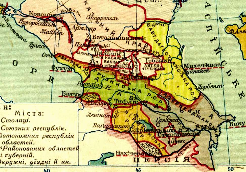
English: Map of the European part of the USSR in 1929. Українська: Мапа европейської частини СРСР на 1929 рік.
Русский: Карта европейской части СССР в 1929 году |
| Date | |
| Source | |
| Author |

| This is a retouched picture, which means that it has been digitally altered from its original version. The original can be viewed here: USSR map Europe.jpg:
|
Licensing
[edit]
This work is in the public domain in Russia according to article 1281 of the Civil Code of the Russian Federation, articles 5 and 6 of Law No. 231-FZ of the Russian Federation of December 18, 2006 (the Implementation Act for Book IV of the Civil Code of the Russian Federation).
This usually means that one of the following conditions is fulfilled.
This work is in the public domain in the United States, because it was in the public domain in its home country (Russia) on the URAA date (January 1, 1996), and it wasn't re-published for 30 days following initial publications in the U.S. [1] If the author of this work was subjected to repression and rehabilitated posthumously, copyright term is counted from January 1 of the year following the year of rehabilitation.
|
|||||
This file is a Ukrainian or Ukrainian SSR work and it is presently in the public domain in Ukraine, because it was published before January 1, 1954, and the creator (if known) died before that date (details).
|
 |
Original upload log
[edit]
This image is a derivative work of the following images:
- File:USSR_map_Europe.jpg licensed with PD-Russia-2008, PD-Ukraine
- 2009-08-05T02:04:49Z Riwnodennyk 2202x3079 (1293045 Bytes) {{Information |Description={{en|1=Map of the European part of the USSR.}} {{uk|1=Мапа европейської частини СРСР.}} |Source=Own work |Author=[[User:Riwnodennyk|Riwnodennyk]] |Date= |Permission= |othe
Uploaded with derivativeFX
File history
Click on a date/time to view the file as it appeared at that time.
| Date/Time | Thumbnail | Dimensions | User | Comment | |
|---|---|---|---|---|---|
| current | 01:01, 19 January 2011 | | 973 × 681 (153 KB) | Geagea (talk | contribs) | == {{int:filedesc}} == {{Information |Description= {{en|1=Map of the European part of the USSR in 1929.}} {{uk|1=Мапа европейської частини СРСР на 1929 рік.}} {{ru|1=Карта европейской части СССР в |
You cannot overwrite this file.
File usage on Commons
There are no pages that use this file.
File usage on other wikis
The following other wikis use this file:
- Usage on cy.wikipedia.org
- Usage on www.wikidata.org
Metadata
- 1929 maps
- Old maps of subdivisions of the Soviet Union
- Maps of European Russia
- 1920s maps of the Soviet Union
- Old maps of Armenia
- 20th-century maps of Azerbaijan
- 20th-century maps of Georgia
- Old maps of Georgian Soviet Socialist Republic
- Old maps of Azerbaijan Soviet Socialist Republic
- Ukrainian-language maps