File:USGS Intensity Map January 1 2024 Anamizu Earthquake M 7.5.pdf
Jump to navigation
Jump to search

Size of this JPG preview of this PDF file: 480 × 599 pixels. Other resolutions: 192 × 240 pixels | 384 × 480 pixels | 615 × 768 pixels | 1,231 × 1,537 pixels.
Original file (1,231 × 1,537 pixels, file size: 3 MB, MIME type: application/pdf)
Captions
Captions
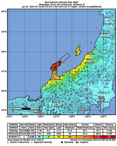
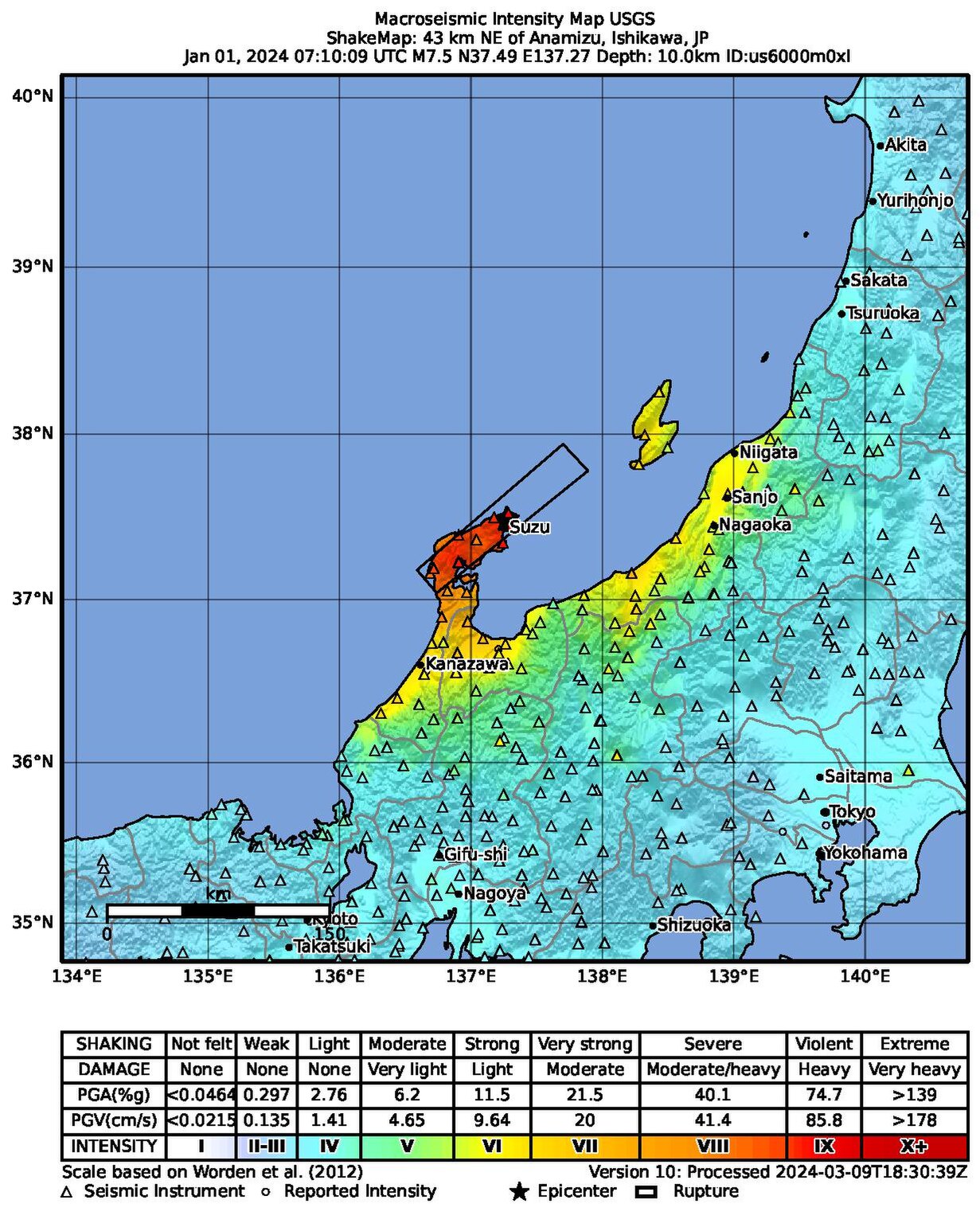
USGS generated seismic intensity map of the 1 January 2024 M 7.5 earthquake that struck Ishikawa, Japan
Summary
[edit]| Description |
English: Macroseismic Intensity Map USGS
ShakeMap: 42 km NE of Anamizu, Ishikawa, JP Jan 01, 2024 07:10:09 UTC M7.5 N37.50 E137.24 Depth: 10.0km ID:us6000m0xl |
| Date | |
| Source | https://earthquake.usgs.gov/product/shakemap/us6000m0xl/us/1710009202676/download/intensity.pdf |
| Author | United States Geological Survey |
Most up-to-date maps:
https://earthquake.usgs.gov/earthquakes/eventpage/us6000m0xl/shakemap/intensity
Licensing
[edit]This image is in the public domain in the United States because it only contains materials that originally came from the United States Geological Survey, an agency of the United States Department of the Interior. For more information, see the official USGS copyright policy.
|
File history
Click on a date/time to view the file as it appeared at that time.
| Date/Time | Thumbnail | Dimensions | User | Comment | |
|---|---|---|---|---|---|
| current | 12:07, 10 March 2024 |  | 1,231 × 1,537 (3 MB) | Sapiann (talk | contribs) | Version 10: Processed 2024-03-09T18:30:39Z |
| 01:33, 9 February 2024 |  | 1,231 × 1,537 (3 MB) | Sapiann (talk | contribs) | Version 8: Processed 2024-01-31T19:30:49Z | |
| 07:09, 31 January 2024 |  | 1,231 × 1,537 (3 MB) | Sapiann (talk | contribs) | Version 7: Processed 2024-01-29T14:39:57Z | |
| 03:15, 3 January 2024 |  | 1,231 × 1,537 (2.99 MB) | Sapiann (talk | contribs) | Version 6: Processed 2024-01-02T18:15:09Z | |
| 09:02, 2 January 2024 |  | 1,237 × 1,558 (2.8 MB) | Sapiann (talk | contribs) | Version 5: Processed 2024-01-02 T07:13:53Z | |
| 19:40, 1 January 2024 |  | 1,237 × 1,558 (2.8 MB) | Sapiann (talk | contribs) | Version 4: Processed 2024-01-01T19:06:40Z | |
| 09:37, 1 January 2024 | 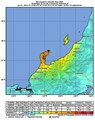 | 1,237 × 1,558 (2.79 MB) | Sapiann (talk | contribs) | Version 3: Processed 2024-01-01 T09:12:40Z | |
| 08:57, 1 January 2024 | 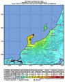 | 1,237 × 1,558 (2.78 MB) | Sapiann (talk | contribs) | Uploaded a work by from United States Geological Survey with UploadWizard |
You cannot overwrite this file.
File usage on Commons
The following page uses this file:
File usage on other wikis
The following other wikis use this file:
- Usage on be.wikipedia.org
- Usage on el.wikipedia.org
- Usage on en.wikipedia.org
- Usage on en.wikiquote.org
- Usage on es.wikipedia.org
- Usage on fa.wikipedia.org
- Usage on fr.wikipedia.org
- Usage on hu.wikipedia.org
- Usage on id.wikipedia.org
- Usage on it.wikipedia.org
- Usage on ja.wikipedia.org
- Usage on la.wikipedia.org
- Usage on mk.wikipedia.org
- Usage on ms.wikipedia.org
- Usage on sl.wikipedia.org
- Usage on th.wikipedia.org
- Usage on tr.wikipedia.org
- Usage on uz.wikipedia.org
- Usage on vi.wikipedia.org
- Usage on www.wikidata.org
- Usage on zh-yue.wikipedia.org
- Usage on zh.wikipedia.org