File:USGS-PP1661d-fig22.png
Jump to navigation
Jump to search
No higher resolution available.
USGS-PP1661d-fig22.png (340 × 411 pixels, file size: 500 KB, MIME type: image/png)
Captions
Captions
Add a one-line explanation of what this file represents
| Description |
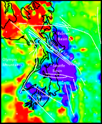
English: Geophysical anomalies and crustal faulting in the Puget Lowland, showing Everett, Tacoma, and Seattle Basins. Bouger gravity anomaly data combined with seismic reflection traveltime data to model rock density at 5 km depth. Blue is the softer, less dense sedimentary deposits, red is the harder, more dense mafic basalt of the Crescent Formation, other colors are intermediate. Black lines are shoreline of Puget Sound, Hood Canal, and the Strait of Juan de Fuca. White dashed lines are crustal faults; faults east of Tacoma Basin are conjectural. |
|||
| Date | Unknown date; approx. 2005. | |||
| Source | http://pubs.usgs.gov/pp/pp1661d/pp1661d.pdf | |||
| Author | U,S. Geological Survey staff | |||
| Permission (Reusing this file) |
|
From USGS Professional Paper 1661-D (2005), "Crustal Structure of the Cascadia Fore Arc of Washington", fig. 22, p. 34.
File history
Click on a date/time to view the file as it appeared at that time.
| Date/Time | Thumbnail | Dimensions | User | Comment | |
|---|---|---|---|---|---|
| current | 23:13, 24 April 2010 | | 340 × 411 (500 KB) | J. Johnson (talk | contribs) | {{Information |Description={{en|1=Geophysical anomalies and crustal faulting in the Puget Lowland, showing Everett, Tacoma, and Seattle Basins. Bouger gravity anomaly data combined with seismic reflection traveltime data to model rock density at 5 km de |
You cannot overwrite this file.
File usage on Commons
There are no pages that use this file.
File usage on other wikis
The following other wikis use this file:
- Usage on en.wikipedia.org
- Usage on it.wikipedia.org