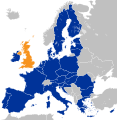
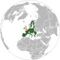
File:Location map of the United Kingdom and the European Union.svg

Original file (SVG file, nominally 593 × 606 pixels, file size: 708 KB)
Captions
Captions
Summary
[edit]| DescriptionLocation map of the United Kingdom and the European Union.svg |
Deutsch: Lage des Vereinigten Königreichs in der Europäischen Union 2016.
English: Location of the United Kingdom and the European Union
|
||||
| Date | |||||
| Source |
This file was derived from: EU Single Market.svg: |
||||
| Author | Furfur | ||||
| Permission (Reusing this file) |
|
||||
| SVG development InfoField | |||||
| Validity/Created with InfoField |
File history
Click on a date/time to view the file as it appeared at that time.
| Date/Time | Thumbnail | Dimensions | User | Comment | |
|---|---|---|---|---|---|
| current | 10:10, 27 December 2022 |  | 593 × 606 (708 KB) | Iktsokh (talk | contribs) | Correction of borders |
| 03:03, 27 March 2019 |  | 593 × 606 (702 KB) | Nice4What (talk | contribs) | Reverted to version as of 08:03, 28 August 2016 (UTC) Northern Cyprus is shown as part as Cyprus in all other EU maps | |
| 16:55, 2 February 2017 |  | 593 × 606 (704 KB) | RaviC (talk | contribs) | Shaded regions with partial EU treaty application (Customs Union) per https://www.gov.uk/government/uploads/system/uploads/attachment_data/file/588948/The_United_Kingdoms_exit_from_and_partnership_with_the_EU_Web.pdf | |
| 05:52, 29 August 2016 |  | 593 × 606 (704 KB) | Turnless (talk | contribs) | Reverted to version as of 12:49, 25 June 2016 (UTC) COM:OVERWRITE violation, you can create a new map if you'd like. | |
| 08:03, 28 August 2016 |  | 593 × 606 (702 KB) | Bazonka (talk | contribs) | Northern Cyprus is de jure part of the EU | |
| 12:49, 25 June 2016 |  | 593 × 606 (704 KB) | Steinsplitter (talk | contribs) | Reverted to version as of 17:57, 18 June 2016 (UTC): COM:OVERWRITE violation | |
| 12:08, 25 June 2016 |  | 792 × 792 (2.87 MB) | ThiefOfBagdad (talk | contribs) | Full EU view | |
| 17:57, 18 June 2016 |  | 593 × 606 (704 KB) | RaviC (talk | contribs) | + Gib | |
| 05:37, 16 June 2016 |  | 593 × 606 (703 KB) | Turnless (talk | contribs) | Update layout | |
| 10:30, 27 May 2016 |  | 632 × 637 (765 KB) | Furfur (talk | contribs) | new color, better visibility |
You cannot overwrite this file.
File usage on Commons
The following 7 pages use this file:
File usage on other wikis
The following other wikis use this file:
- Usage on af.wikipedia.org
- Usage on ar.wikipedia.org
- Usage on ast.wikipedia.org
- Usage on az.wikipedia.org
- Usage on bar.wikipedia.org
- Usage on ba.wikipedia.org
- Usage on be.wikipedia.org
- Usage on bg.wikipedia.org
- Usage on bh.wikipedia.org
- Usage on bn.wikipedia.org
- Usage on br.wikipedia.org
- Usage on bs.wikipedia.org
- Usage on cs.wikipedia.org
- Usage on cy.wikipedia.org
- Usage on da.wikipedia.org
- Usage on de.wikipedia.org
- 2016
- Benutzer:Kallewirsch
- EU-Austritt des Vereinigten Königreichs
- Benutzer:Tmid
- Benutzer:Anton-kurt/Schaufenster 2016
- Wikipedia:Hauptseite/Archiv/24. Juni 2016
- Wikipedia:Hauptseite/Archiv/3. November 2016
- März 2017
- Wikipedia:Hauptseite/Archiv/29. März 2017
- Wikipedia:Kartenwerkstatt/Archiv/2017-04
- Wikipedia:Hauptseite/Archiv/20. Juni 2017
- Wikipedia:Hauptseite/Archiv/15. November 2018
- Wikipedia:Hauptseite/Archiv/25. November 2018
- Wikipedia:Hauptseite/Archiv/26. November 2018
- EU-Mitgliedschaft des Vereinigten Königreichs
- Wikipedia:Kurier/Ausgabe 2 2020
- Handels- und Kooperationsabkommen zwischen der Europäischen Union und dem Vereinigten Königreich
- Benutzer:Gabas/Meistaufgerufene Artikel
- Usage on din.wikipedia.org
- Usage on diq.wikipedia.org
- Usage on en.wikipedia.org
- User:ArcMachaon/sandbox
- Brexit
- Wikipedia:In the news/Candidates/June 2016
- Template talk:United Kingdom in the European Union
- Wikipedia:Top 25 Report/June 19 to 25, 2016
- Wikipedia:Wikipedia Signpost/2016-07-04/Traffic report
- Wikipedia:Wikipedia Signpost/Single/2016-07-04
- Wikipedia:Top 25 Report/June 26 to July 2, 2016
- Talk:Brexit/Archive 1
View more global usage of this file.
Metadata
This file contains additional information such as Exif metadata which may have been added by the digital camera, scanner, or software program used to create or digitize it. If the file has been modified from its original state, some details such as the timestamp may not fully reflect those of the original file. The timestamp is only as accurate as the clock in the camera, and it may be completely wrong.
| Short title | Countries of Europe |
|---|---|
| Image title | A blank Map of Europe. Every country has an id which is its ISO-3166-1-ALPHA2 code in lower case.
Members of the EU have a class="eu", countries in europe (which I found turkey to be but russia not) have a class="europe".
Certain countries are further subdivided the United Kingdom has gb-gbn for Great Britain and gb-nir for Northern Ireland. Russia is divided into ru-kgd for the Kaliningrad Oblast and ru-main for the Main body of Russia. There is the additional grouping #xb for the "British Islands" (the UK with its Crown Dependencies - Jersey, Guernsey and the Isle of Man) and the Kingdom of Denmark (Denmark, Faroe Islands, Greenland)

Contributors.
Original Image: (http://commons.wikimedia.org/wiki/Image:Europe_countries.svg) Júlio Reis (http://commons.wikimedia.org/wiki/User:Tintazul).
Recolouring and tagging with country codes: Marian "maix" Sigler (http://commons.wikimedia.org/wiki/User:Maix)
Improved geographical features: http://commons.wikimedia.org/wiki/User:W!B:
Updated to reflect dissolution of Serbia & Montenegro: http://commons.wikimedia.org/wiki/User:Zirland
Updated to include British Crown Dependencies as seperate entities and regroup them as "British Islands", with some simplifications to the XML and CSS: James Hardy (http://commons.wikimedia.org/wiki/User:MrWeeble)
Validated (http://commons.wikimedia.org/wiki/User:CarolSpears)
Changed the country code of Serbia to RS per http://en.wikipedia.org/wiki/Serbian_country_codes and the file http://www.iso.org/iso/iso3166_en_code_lists.txt (http://commons.wikimedia.org/wiki/User:TimothyBourke)
Uploaded on behalf of User:Checkit, direct complaints to him plox: 'Moved countries out of the "outlines" group, removed "outlines" style class, remove separate style information for Russia' (http://commons.wikimedia.org/wiki/User:Collard)
Updated various coastlines and boarders and added various islands not previously shown (details follow). Added Kosovo, Northern Cyprus, Crimea, Abkhazia, South Ossetia, Transnistria and Nagorno-Karabakh as disputed territories. Moved major lakes to their own object and added more. List of updated boarders/coastlines: British Isles (+ added Isle of Wight, Skye, various smaller islands), the Netherlands, Germany, Austria, Hungary, Czech Republic, Denmark, Sweden, Finland, Poland, Kaliningrad Oblast of the Russian Federation (and minor tweaks to Lithuania), Estonia, Ukraine, Moldova (minor), Romania, Bulgaria, Turkey, Greece, F.Y.R. Macedonia, Serbia, Bosnia and Herzegovina, Montenegro, Albania, Croatia, Italy (mainland and Sicily), Malta (http://commons.wikimedia.org/wiki/User:Alphathon).
Added Bornholm (http://commons.wikimedia.org/wiki/User:Heb)
Released under CreativeCommons Attribution ShareAlike (http://creativecommons.org/licenses/by-sa/2.5/). |
| Width | 593 |
| Height | 606 |