File:UKAEA monitoring station - geograph.org.uk - 385913.jpg
Jump to navigation
Jump to search
No higher resolution available.
UKAEA_monitoring_station_-_geograph.org.uk_-_385913.jpg (640 × 480 pixels, file size: 144 KB, MIME type: image/jpeg)
Captions
Captions
Add a one-line explanation of what this file represents
Summary
[edit]
| Description |
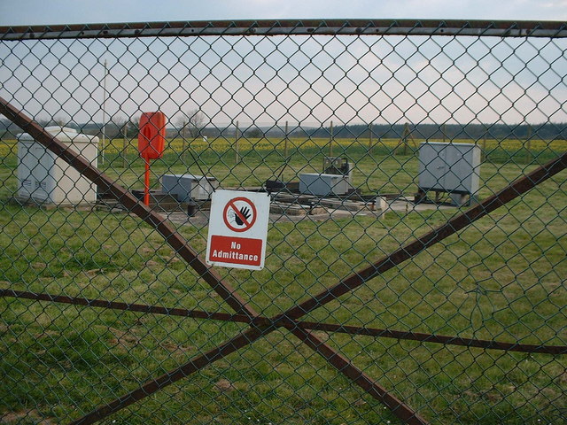
English: UKAEA monitoring station Apart from the keep out signs, there is no explanation of what station is for. The red stand houses a safety line, so there must be deep or open water somewhere here. This notice 385887 identifies it as a monitoring station for the UK Atomic Energy Authority. They own the nuclear power plant at Winfrith Heath. The waste water from that plant is pumped underneath Lulworth Park and out to sea at the gap in the chalk hills at Arish Mell. |
| Date | |
| Source | From geograph.org.uk |
| Author | David Hodd |
| Attribution (required by the license) | David Hodd / UKAEA monitoring station / |
| Camera location | | View this and other nearby images on: OpenStreetMap |
|---|
_heading:180.00&language=en)
| Object location | | View this and other nearby images on: OpenStreetMap |
|---|
_heading:180.00&language=en)
Licensing
[edit]

|
This image was taken from the Geograph project collection. See this photograph's page on the Geograph website for the photographer's contact details. The copyright on this image is owned by David Hodd and is licensed for reuse under the Creative Commons Attribution-ShareAlike 2.0 license.
|
This file is licensed under the Creative Commons Attribution-Share Alike 2.0 Generic license.
Attribution: David Hodd
- You are free:
- to share – to copy, distribute and transmit the work
- to remix – to adapt the work
- Under the following conditions:
- attribution – You must give appropriate credit, provide a link to the license, and indicate if changes were made. You may do so in any reasonable manner, but not in any way that suggests the licensor endorses you or your use.
- share alike – If you remix, transform, or build upon the material, you must distribute your contributions under the same or compatible license as the original.
File history
Click on a date/time to view the file as it appeared at that time.
| Date/Time | Thumbnail | Dimensions | User | Comment | |
|---|---|---|---|---|---|
| current | 15:45, 3 February 2011 | | 640 × 480 (144 KB) | GeographBot (talk | contribs) | == {{int:filedesc}} == {{Information |description={{en|1=UKAEA monitoring station Apart from the keep out signs, there is no explanation of what station is for. The red stand houses a safety line, so there must be deep or open water somewhere here. This n |
You cannot overwrite this file.
File usage on Commons
There are no pages that use this file.