File:UBBasel Map 1544 Kartenslg Schw Ml 3 Rauracher Land samt Basel.tiff
Jump to navigation
Jump to search

Size of this JPG preview of this TIF file: 800 × 371 pixels. Other resolutions: 320 × 148 pixels | 640 × 297 pixels | 1,024 × 475 pixels | 1,280 × 594 pixels | 2,560 × 1,187 pixels | 14,683 × 6,809 pixels.

Original file (14,683 × 6,809 pixels, file size: 286.06 MB, MIME type: image/tiff, 2 pages)
Captions
Captions
Add a one-line explanation of what this file represents
Summary
[edit]| Warning | The original file is very high-resolution. It might not load properly or could cause your browser to freeze when opened at full size. |
|---|
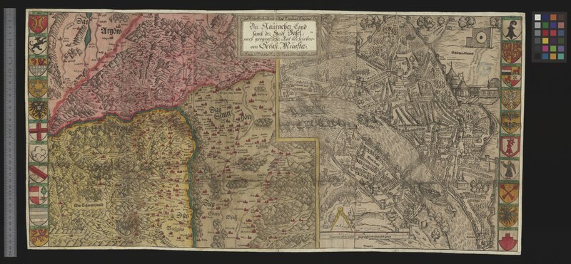
| Title |
Der Rauracher Land samt der Stadt Basel |
|||||||||||||||||||||||
| Description |
Der Rauracher Land samt der Stadt Basel / nach geografischer Art beschrieben von Sebast. Münster |
|||||||||||||||||||||||
| Date | ||||||||||||||||||||||||
| Source | 10.3931/e-rara-12948 : Info: Kartenportal.CH | |||||||||||||||||||||||
| Creator |
Sebastian Münster (1488-1552) |
|||||||||||||||||||||||
| Permission (Reusing this file) |
|
|||||||||||||||||||||||
| Geotemporal data | ||||||||||||||||||||||||
| Scale | 1. Karte: ca. 1:230 000; 2. Karte: ca. 1:5 000 | |||||||||||||||||||||||
| Bounding box | ||||||||||||||||||||||||
| Georeferencing | If inappropriate please set warp_status = skip to hide. | |||||||||||||||||||||||
| Bibliographic data | ||||||||||||||||||||||||
| Language | ger | |||||||||||||||||||||||
| Printed by |
Basel, Heinrich Petri |
|||||||||||||||||||||||
| Archival data | ||||||||||||||||||||||||
| Collection |
|
|||||||||||||||||||||||
| Accession number |
Basel UB, Kartenslg Schw Ml 3 |
|||||||||||||||||||||||
| Dimensions | 39 × 75 cm (15.3 × 29.5 in) | |||||||||||||||||||||||
| Medium | Holzschnitt | |||||||||||||||||||||||
| Notes | Titelkartusche oben in der Mitte / 1. Karte: Gegend von Aargau, Schwarzwald bis Elsass (Koordinaten: E 7°20'-E 8°15'/N 48°03'-N 47°13'); 2. Karte: Vogelschauplan von Basel (Koordinaten: E 7°34'-E 7°37'/N 47°35'-N 47°32') / Südorientiert / Wappenleisten links und rechts der Karte | |||||||||||||||||||||||


File history
Click on a date/time to view the file as it appeared at that time.
| Date/Time | Thumbnail | Dimensions | User | Comment | |
|---|---|---|---|---|---|
| current | 14:30, 18 August 2015 |  | 14,683 × 6,809, 2 pages (286.06 MB) | Basel University Library (talk | contribs) | GWToolset: Creating mediafile for Basel University Library. |
You cannot overwrite this file.
File usage on Commons
The following 2 pages use this file: