File:Trossin, Rittergut (23).jpg
Jump to navigation
Jump to search

Size of this preview: 357 × 599 pixels. Other resolutions: 143 × 240 pixels | 286 × 480 pixels | 458 × 768 pixels | 610 × 1,024 pixels | 1,221 × 2,048 pixels | 2,996 × 5,026 pixels.
Original file (2,996 × 5,026 pixels, file size: 2.85 MB, MIME type: image/jpeg)
Captions
Captions
Add a one-line explanation of what this file represents
Summary
[edit].jpg&action=edit§ion=1)
| Description |
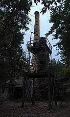
Deutsch: Rittergut und Gutspark in Trossin, Unter den Linden, Panoramaansicht des Gutshauses/Schloss Barockbau mit dreiachsigem Mittelrisalit und Eckpavillons mit Walmdach, baugeschichtlich und ortsgeschichtlich und landschaftsgestaltend von Bedeutung; Kulturdenkmal;
im Foto: Maschine am Schornstein des westlichen Wirtschaftsgebäudes
English: Manor and park in Trossin, Unter den Linden, Mansion: Panoramic view of the mansion Château Baroque building with three-axle middle avant-corps and corner pavilion with hipped roof, building history and local history and landscaping of importance; cultural heritage monument;
in the photo: machine near the chimney of the western farm building |
||
| Date | |||
| Source | Own work | ||
| Author | Tommes | ||
| Bearbeitungen |
|

|
NOTE: This image is a panorama of „Teil des Rittergutes in Trossin“ consisting of 2 frames that were merged or stitched in Image Composite Editor. As a result, this image necessarily underwent some form of digital manipulation. These manipulations may include blending, blurring, cloning, and colour and perspective adjustments. As a result of these adjustments, the image content may be slightly different from reality at the points where multiple images were combined. This manipulation is often required due to lens, perspective, and parallax distortions.
|
| Camera location | | View this and other nearby images on: OpenStreetMap |
|---|
.jpg¶ms=051.616042_N_0012.825067_E_globe:Earth_type:camera_alt:109.9_source:exif_heading:143.12&language=en)
| Object location | | View this and other nearby images on: OpenStreetMap |
|---|
.jpg¶ms=051.615985_N_0012.825144_E_globe:Earth_class:object_type:object__&language=en)
Licensing
[edit].jpg&action=edit§ion=2)
I, the copyright holder of this work, hereby publish it under the following license:
This file is licensed under the Creative Commons Attribution-Share Alike 4.0 International license.
- You are free:
- to share – to copy, distribute and transmit the work
- to remix – to adapt the work
- Under the following conditions:
- attribution – You must give appropriate credit, provide a link to the license, and indicate if changes were made. You may do so in any reasonable manner, but not in any way that suggests the licensor endorses you or your use.
- share alike – If you remix, transform, or build upon the material, you must distribute your contributions under the same or compatible license as the original.
File history
Click on a date/time to view the file as it appeared at that time.
| Date/Time | Thumbnail | Dimensions | User | Comment | |
|---|---|---|---|---|---|
| current | 10:25, 10 November 2018 | | 2,996 × 5,026 (2.85 MB) | Tommes (talk | contribs) | == {{int:filedesc}} == {{Information |Description = {{de|1=Rittergut und Gutspark in Trossin, Unter den Linden, Panoramaansicht des Gutshauses/Schloss Barockbau mit dreiachsigem Mittelrisalit und Eckpavillons mit Walmdach, baugeschichtlich und ortsgeschichtlich und landschaftsgestaltend von Bedeutung; Kulturdenkmal; im Foto: Maschine am Schornstein des westlichen Wirtschaftsgebäudes}} {{en|1=Manor and park in Trossin, Unter den Linden, Mansion: Panoramic vi... |
You cannot overwrite this file.
File usage on Commons
There are no pages that use this file.
.jpg&oldid=546325679)