File:Triple occupation of Greece de.svg
Jump to navigation
Jump to search

Size of this PNG preview of this SVG file: 638 × 600 pixels. Other resolutions: 255 × 240 pixels | 511 × 480 pixels | 817 × 768 pixels | 1,090 × 1,024 pixels | 2,180 × 2,048 pixels | 812 × 763 pixels.
Original file (SVG file, nominally 812 × 763 pixels, file size: 109 KB)
Captions
Captions
Add a one-line explanation of what this file represents
Summary
[edit]| Description |
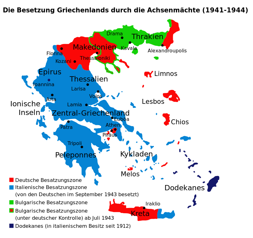
Deutsch: Besetzung Griechenlands während des Zweiten Weltkriegs durch die Achsenmächte und Verbündete.
Ελληνικά: Χάρτης των ζωνών κατοχής της Ελλάδος από τις δυνάμεις του Άξονα (Γερμανια, Ιταλία, Βουλγαρία) κατά τον Β' ΠΠ.
English: Map of the 1941-1944 Axis Occupation of Greece. Depicted are the three occupation zones, plus the geographic regions and major urban centres.
Français : La triple occupation de la Grèce pendant la Seconde Guerre mondiale (1941-1945)
Italiano: Zone di occupazione tedesche, italiane e bulgare della Grecia durante la Seconda guerra mondiale
Polski: Okupacja Grecji (1941-1945) |
||
| Date | |||
| Source | Triple occuppation of Greece el.svg, made by infosfinaki (based on Triple occuppation of Greece.png, made by Cplakidas) | ||
| Author | Furfur | ||
| Permission (Reusing this file) |
|
||
| Other versions |
[]
|
||
| Validation/Created with | This vector image was created with Inkscape . |


_-fr.png)


File history
Click on a date/time to view the file as it appeared at that time.
| Date/Time | Thumbnail | Dimensions | User | Comment | |
|---|---|---|---|---|---|
| current | 01:21, 23 August 2021 | | 812 × 763 (109 KB) | Praça de Maio (talk | contribs) | File uploaded using svgtranslate tool (https://svgtranslate.toolforge.org/). Added translation for tr. |
| 15:51, 4 March 2016 |  | 812 × 763 (92 KB) | Furfur (talk | contribs) | SVG-Fehler eliminiert, jetzt gültiger SVG code | |
| 15:39, 4 March 2016 |  | 812 × 763 (92 KB) | Furfur (talk | contribs) | Fehlerkorrekturen | |
| 15:14, 14 September 2013 |  | 1,158 × 1,147 (74 KB) | Furfur (talk | contribs) | Euböa ergänzt, kleinere Änderungen | |
| 15:09, 14 September 2013 |  | 1,158 × 1,147 (74 KB) | Furfur (talk | contribs) | Bildkosmetik + kleinere Fehler | |
| 15:01, 14 September 2013 |  | 1,158 × 1,147 (74 KB) | Furfur (talk | contribs) | {{Information |Description={{de|1=Besetzung Griechenlands während des Zweiten Weltkriegs durch die Achsenmächte und Verbündete.}} {{el|1=Χάρτης των ζωνών κατοχής της Ελλάδος από τις δυνάμεις του Άξο... |
You cannot overwrite this file.
File usage on Commons
The following 18 pages use this file:
- User:Magog the Ogre/Maps of conflicts/2016 March
- User:Magog the Ogre/Maps of conflicts/2021 August
- File:Gr-triple-occupation-ES.png
- File:Gr-triple-occupation-gr.png
- File:Gr-triple-occupation-Česky.JPG
- File:Gr-triple-occupation.png
- File:Occupation-de-la-grece-he.png
- File:Occupation de la grece (1941-1944) -fr.png
- File:PL-triple-occupation.png
- File:Tripla occupazione greca.gif
- File:Triple Occupation of Greece.png
- File:Triple occupation of Greece-zh.svg
- File:Triple occupation of Greece de.svg
- File:Triple occupation of Greece el.svg
- File:Triple occupation of Greece es.svg
- File:Triple occupation of Greece mk.svg
- File:Triple occuppation of Greece de.svg (file redirect)
- Template:Other versions/Occupation of Greece
File usage on other wikis
The following other wikis use this file:
- Usage on de.wikipedia.org
- Usage on sq.wikipedia.org
- Usage on tr.wikipedia.org