File:TriânguloMineiro.png
Jump to navigation
Jump to search
No higher resolution available.
TriânguloMineiro.png (358 × 358 pixels, file size: 283 KB, MIME type: image/png)
Captions
Captions
Add a one-line explanation of what this file represents
Summary
[edit]| Description |
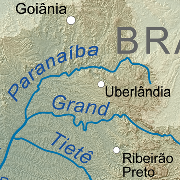
Português: O Triângulo Mineiro como região natural, limitada pelos rios Paranaíba, a norte, e Grande, a sul, e, a este, pelo limite da bacia hidrográfica do rio Paraná.
Español: El Triángulo Mineiro como región natural, limitado por los ríos Paranaíba al norte, y Grande al sur, y al este, por el límite de la cuenca hidrográfica del río Paraná.
English: The Triângulo Mineiro as a natural region, limited by the Paranaíba river to the north, and the Grande river to the south, and to the east, by the limit of the Paraná river basin. |
| Date | |
| Source | Own work, Elevation data from SRTM, drainage basin from GTOPO [1], all other features from Vector Map. |
| Author | Kmusser |
| Other versions |

Licensing
[edit]
I, the copyright holder of this work, hereby publish it under the following license:
This file is licensed under the Creative Commons Attribution-Share Alike 3.0 Unported license.
- You are free:
- to share – to copy, distribute and transmit the work
- to remix – to adapt the work
- Under the following conditions:
- attribution – You must give appropriate credit, provide a link to the license, and indicate if changes were made. You may do so in any reasonable manner, but not in any way that suggests the licensor endorses you or your use.
- share alike – If you remix, transform, or build upon the material, you must distribute your contributions under the same or compatible license as the original.
File history
Click on a date/time to view the file as it appeared at that time.
| Date/Time | Thumbnail | Dimensions | User | Comment | |
|---|---|---|---|---|---|
| current | 21:07, 15 October 2018 | | 358 × 358 (283 KB) | Tuvalkin (talk | contribs) | File:Riodelaplatabasinmap.png cropped 76 % horizontally, 76 % vertically using CropTool with precise mode. |
You cannot overwrite this file.
File usage on Commons
The following 2 pages use this file:
File usage on other wikis
The following other wikis use this file:
- Usage on de.wikipedia.org
- Usage on es.wikipedia.org
- Usage on fr.wikipedia.org
- Usage on www.wikidata.org