File:Treaty of Lochaber.jpg
Jump to navigation
Jump to search

Size of this preview: 660 × 599 pixels. Other resolutions: 264 × 240 pixels | 529 × 480 pixels | 846 × 768 pixels | 1,128 × 1,024 pixels | 2,255 × 2,048 pixels | 4,160 × 3,778 pixels.
Original file (4,160 × 3,778 pixels, file size: 2.43 MB, MIME type: image/jpeg)
Captions
Captions
Add a one-line explanation of what this file represents
Summary
[edit]
| Description |
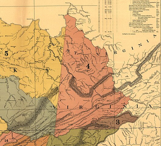
English: The Treaty of Lochaber was signed in South Carolina on 18 October 1770 by British representative John Stuart and the Cherokee people, fixing the boundary for the western limit of the colonial frontier settlements of Virginia and North Carolina. |
| Date | |
| Source | File:Map of the former territorial limits of the Cherokee "Nation of" Indians ; Map showing the territory originally assigned Cherokee "Nation of" Indians. LOC 99446145.jpg (crop) |
| Author | Royce, C. C. |
Licensing
[edit]
This work is in the public domain in the United States because it was published (or registered with the U.S. Copyright Office) before January 1, 1929.
Public domain works must be out of copyright in both the United States and in the source country of the work in order to be hosted on the Commons. If the work is not a U.S. work, the file must have an additional copyright tag indicating the copyright status in the source country.
Note: This tag should not be used for sound recordings. |
File history
Click on a date/time to view the file as it appeared at that time.
| Date/Time | Thumbnail | Dimensions | User | Comment | |
|---|---|---|---|---|---|
| current | 18:24, 2 July 2024 | | 4,160 × 3,778 (2.43 MB) | Muhranoff (talk | contribs) | Uploaded a work by Royce, C. C. from File:Map of the former territorial limits of the Cherokee "Nation of" Indians ; Map showing the territory originally assigned Cherokee "Nation of" Indians. LOC 99446145.jpg (crop) with UploadWizard |
You cannot overwrite this file.
File usage on Commons
There are no pages that use this file.
File usage on other wikis
The following other wikis use this file:
- Usage on ru.wikipedia.org