File:TramCCFLmapa(pt).svg
(Redirected from File:Tram tracks map Lisbon.svg)

Size of this PNG preview of this SVG file: 800 × 577 pixels. Other resolutions: 320 × 231 pixels | 640 × 462 pixels | 1,024 × 739 pixels | 1,280 × 924 pixels | 2,560 × 1,848 pixels | 1,258 × 908 pixels.
Original file (SVG file, nominally 1,258 × 908 pixels, file size: 1.66 MB)
Captions
Captions
Add a one-line explanation of what this file represents
Summary
[edit].svg&action=edit§ion=1)
| Description |
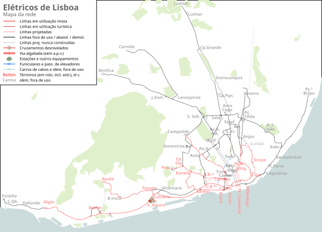
English: Map of Tram tracks in Lisbon, svg version.
Deutsch: Streckennetzplan der Straßenbahn von Lissabon, svg-Version. |
| Source | Own work, with data from Open Street Map |
| Author |

|
This file may be updated to reflect new information. If you wish to use a specific version of the file without it being overwritten, please upload the required version as a separate file. |
Licensing
[edit].svg&action=edit§ion=2)
I, the copyright holder of this work, hereby publish it under the following license:
This file is licensed under the Creative Commons Attribution-Share Alike 2.0 Generic license.
- You are free:
- to share – to copy, distribute and transmit the work
- to remix – to adapt the work
- Under the following conditions:
- attribution – You must give appropriate credit, provide a link to the license, and indicate if changes were made. You may do so in any reasonable manner, but not in any way that suggests the licensor endorses you or your use.
- share alike – If you remix, transform, or build upon the material, you must distribute your contributions under the same or compatible license as the original.
Any autoconfirmed user can overwrite this file from the same source. Please ensure that overwrites comply with the guideline.
File history
Click on a date/time to view the file as it appeared at that time.
.svg&dir=prev)
.svg&offset=20120616190712)
.svg&offset=&limit=20)
.svg&offset=&limit=50)
.svg&offset=&limit=100)
.svg&offset=&limit=250)
.svg&offset=&limit=500)
| Date/Time | Thumbnail | Dimensions | User | Comment | |
|---|---|---|---|---|---|
| current | 22:54, 7 January 2019 | | 1,258 × 908 (1.66 MB) | Tuvalkin (talk | contribs) | S.Amaro (compl.); pj. Aeroporto (acresc.); Arroios-Areeiro via Alves Torgo (acresc./corr.) |
| 06:36, 6 December 2018 |  | 1,258 × 908 (1.06 MB) | Tuvalkin (talk | contribs) | Corr.: Graça, Prazeres, S.Amaro, Carmo. Atu.: C.Santo; C.Sodré. Acres.: pj. Estádio SLB. | |
| 22:31, 13 July 2018 |  | 1,258 × 908 (1.05 MB) | Tuvalkin (talk | contribs) | transparency | |
| 23:40, 12 July 2018 |  | 1,258 × 908 (1.06 MB) | Tuvalkin (talk | contribs) | O vinte-e-quatro!! | |
| 17:12, 14 June 2015 |  | 1,258 × 908 (1.05 MB) | Tuvalkin (talk | contribs) | Chiado Tram Tour; corr. Lavra! | |
| 01:27, 8 December 2014 |  | 1,258 × 908 (1.05 MB) | Tuvalkin (talk | contribs) | improved legend; background restored; changed colors for other railways; lots of small additions and corrections (work in progress) | |
| 01:13, 25 November 2014 |  | 1,258 × 908 (1.04 MB) | Tuvalkin (talk | contribs) | lots of small additions and corrections (work in progress) | |
| 19:26, 13 July 2014 |  | 1,258 × 908 (1.03 MB) | Tuvalkin (talk | contribs) | lots of small additions and corrections (work in progress) | |
| 13:39, 13 July 2012 |  | 1,258 × 908 (255 KB) | Tuvalkin (talk | contribs) | Double track redrawn to show two parallel lines; Misc. corrections; Some typos fixed; Some detail added; Some vectorial fixes; Funiculars added; (work in progress) | |
| 19:07, 16 June 2012 |  | 1,258 × 908 (257 KB) | Tuvalkin (talk | contribs) | raster layer removed |
You cannot overwrite this file.
File usage on Commons
The following 23 pages use this file:
- User:Chumwa/OgreBot/Potential transport maps/2018 December 1-10
- User:Chumwa/OgreBot/Potential transport maps/2018 July 11-20
- User:Chumwa/OgreBot/Potential transport maps/2019 January 1-10
- User:Chumwa/OgreBot/Public transport information/2015 June 11-20
- User:Chumwa/OgreBot/Public transport information/2018 December 1-10
- User:Chumwa/OgreBot/Public transport information/2018 July 11-20
- User:Chumwa/OgreBot/Public transport information/2019 January 1-10
- User:Chumwa/OgreBot/Transport Maps/2015 June 11-20
- User:Chumwa/OgreBot/Transport Maps/2018 December 1-10
- User:Chumwa/OgreBot/Transport Maps/2018 July 11-20
- User:Chumwa/OgreBot/Transport Maps/2019 January 1-10
- User:Chumwa/OgreBot/Travel and communication maps/2018 December 1-10
- User:Chumwa/OgreBot/Travel and communication maps/2018 July 11-20
- User:Chumwa/OgreBot/Travel and communication maps/2019 January 1-10
- User:Jcornelius/Portugal Public Transport/2015 June 11-20
- User:Jcornelius/Portugal Public Transport/2018 December 1-10
- User:Jcornelius/Portugal Public Transport/2018 July 11-20
- User:Jcornelius/Portugal Public Transport/2019 January 1-10
- File:Tram tracks map Lisbon.png
- File:Tram tracks map Lisbon.svg (file redirect)
- Category:Trams in Lisbon
- Category:Views from Lisbon trams
File usage on other wikis
The following other wikis use this file:
- Usage on de.wikipedia.org
- Usage on en.wikipedia.org
- Usage on it.wikipedia.org
- Usage on pl.wikipedia.org
- Usage on pt.wikipedia.org
- Usage on sv.wikipedia.org
- Usage on uk.wikipedia.org
- Usage on www.wikidata.org
.svg&oldid=822599156)