File:Tracking the Spread of the Caldor and Dixie Fires (SVS5088 - Tracking the Caldor and Dixie Fires).webm
Jump to navigation
Jump to search
Size of this JPG preview of this WEBM file: 800 × 450 pixels. Other resolutions: 320 × 180 pixels | 640 × 360 pixels | 1,024 × 576 pixels | 1,280 × 720 pixels | 1,920 × 1,080 pixels.
Original file (WebM audio/video file, VP8/Opus, length 2 min 26 s, 1,920 × 1,080 pixels, 3.82 Mbps overall, file size: 66.44 MB)
Captions
Captions
Add a one-line explanation of what this file represents
Summary
[edit]| Description |
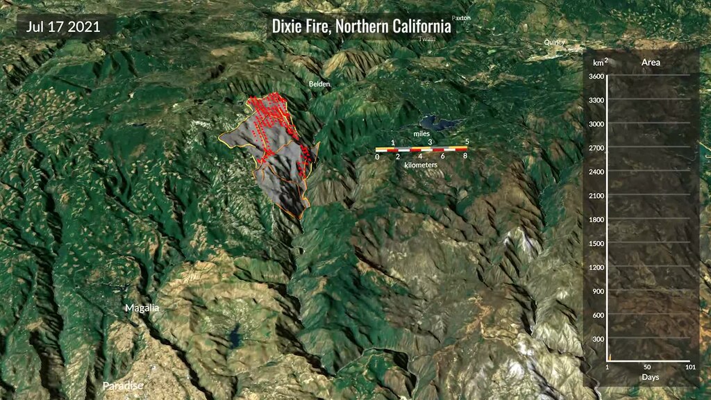
English: This visualization shows the spread of the Caldor and the Dixie fires in California during the summer of 2021, updated every 12 hours from a new fire detection and tracking approach based on near-real time active fire detections from the VIIRS sensor on the Suomi-NPP satellite.Complete transcript available. |
| Date | 12 June 2023 (upload date) |
| Source | Tracking the Spread of the Caldor and Dixie Fires |
| Author | NASA's Scientific Visualization Studio - Cindy Starr, Alex Kekesi, Andrew J Christensen, Greg Shirah, Horace Mitchell, Kel Elkins, Michala Garrison, Doug C. Morton, Ian Jones, Laurence Schuler |
| Other versions |
|
| Keywords | Earth Science; Human geography; Human Dimensions; Fire Occurrence; Environmental Governance/management; Ecological Dynamics; Fires; Hyperwall; Biosphere; Fire Management; Natural hazards |
Licensing
[edit]| This file is in the public domain in the United States because it was solely created by NASA. NASA copyright policy states that "NASA material is not protected by copyright unless noted". (See Template:PD-USGov, NASA copyright policy page or JPL Image Use Policy.) | ||
 |
Warnings:
|
File history
Click on a date/time to view the file as it appeared at that time.
| Date/Time | Thumbnail | Dimensions | User | Comment | |
|---|---|---|---|---|---|
| current | 11:09, 6 September 2023 | 2 min 26 s, 1,920 × 1,080 (66.44 MB) | OptimusPrimeBot (talk | contribs) | #Spacemedia - Upload of https://svs.gsfc.nasa.gov/vis/a000000/a005000/a005088/Tracking_the_Caldor_and_Dixie_Fires.webm via Commons:Spacemedia |
You cannot overwrite this file.
File usage on Commons
The following 5 pages use this file:
- File:Tracking the Spread of the Caldor and Dixie Fires (SVS5088 - 4k fires both-01).png
- File:Tracking the Spread of the Caldor and Dixie Fires (SVS5088 - Caldor fire 2021 4000).tiff
- File:Tracking the Spread of the Caldor and Dixie Fires (SVS5088 - Caldor fire 2021 6540).tiff
- File:Tracking the Spread of the Caldor and Dixie Fires (SVS5088 - Dixie fire 2021 2500).tiff
- File:Tracking the Spread of the Caldor and Dixie Fires (SVS5088 - Dixie fire 2021 7135).tiff
.png)