File:Toxicodendron vernix map.png
Jump to navigation
Jump to search
Size of this preview: 535 × 599 pixels. Other resolutions: 214 × 240 pixels | 540 × 605 pixels.
Original file (540 × 605 pixels, file size: 111 KB, MIME type: image/png)
Captions
Captions
Add a one-line explanation of what this file represents
Summary
[edit]
| Description |
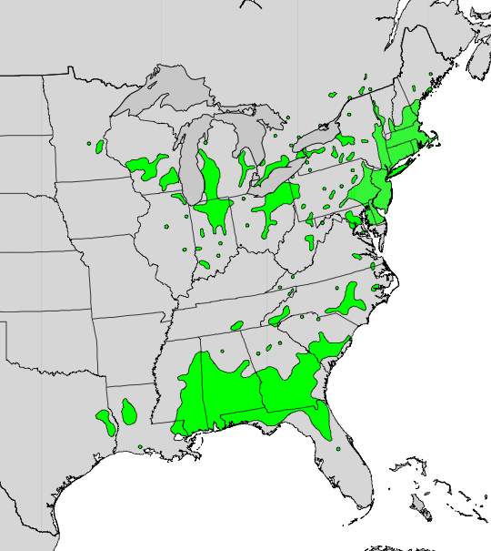
English: Range map of Toxicodendron vernix |
| Date | |
| Source | Digital representation of "Atlas of United States Trees" by Elbert L. Little, Jr. [1] |
| Author | U.S. Geological Survey |
Licensing
[edit]
This image is in the public domain in the United States because it only contains materials that originally came from the United States Geological Survey, an agency of the United States Department of the Interior. For more information, see the official USGS copyright policy.
|
Original upload log
[edit]
The original description page was here. All following user names refer to en.wikipedia.
- 2010-05-12 05:06 Masebrock 540×605× (114133 bytes) {{Information |Description=Range map of Toxicodendron vernix |Source=Digital representation of "Atlas of United States Trees" by Elbert L. Little, Jr. [http://esp.cr.usgs.gov/data/atlas/little/] |Date=1999 |Author=U.S. Geological Survey |Permission={{PD-U
File history
Click on a date/time to view the file as it appeared at that time.
| Date/Time | Thumbnail | Dimensions | User | Comment | |
|---|---|---|---|---|---|
| current | 16:13, 13 October 2015 | | 540 × 605 (111 KB) | Luke (talk | contribs) | User created page with UploadWizard |
You cannot overwrite this file.
File usage on Commons
There are no pages that use this file.
File usage on other wikis
The following other wikis use this file:
- Usage on ceb.wikipedia.org
- Usage on de.wikipedia.org
- Usage on en.wikipedia.org
- Usage on fa.wikipedia.org
- Usage on sv.wikipedia.org