File:TotalTimingSystem.png
Original file (1,650 × 2,550 pixels, file size: 2.29 MB, MIME type: image/png)
Captions
Captions
Summary
[edit]
| Description |
English: The bottom part is a CIA worldbook map. |
| Date | |
| Source | The top part is basically my upload File:TotalTimingSystem.JPG. The bottom part is a CIA worldbook map. |
| Author | https://www.cia.gov/library/publications/the-world-factbook/geos/it.html |
| Permission (Reusing this file) |
Licensing
[edit]
This image is in the public domain because it contains materials that originally came from the United States Central Intelligence Agency's World Factbook.
|
 |
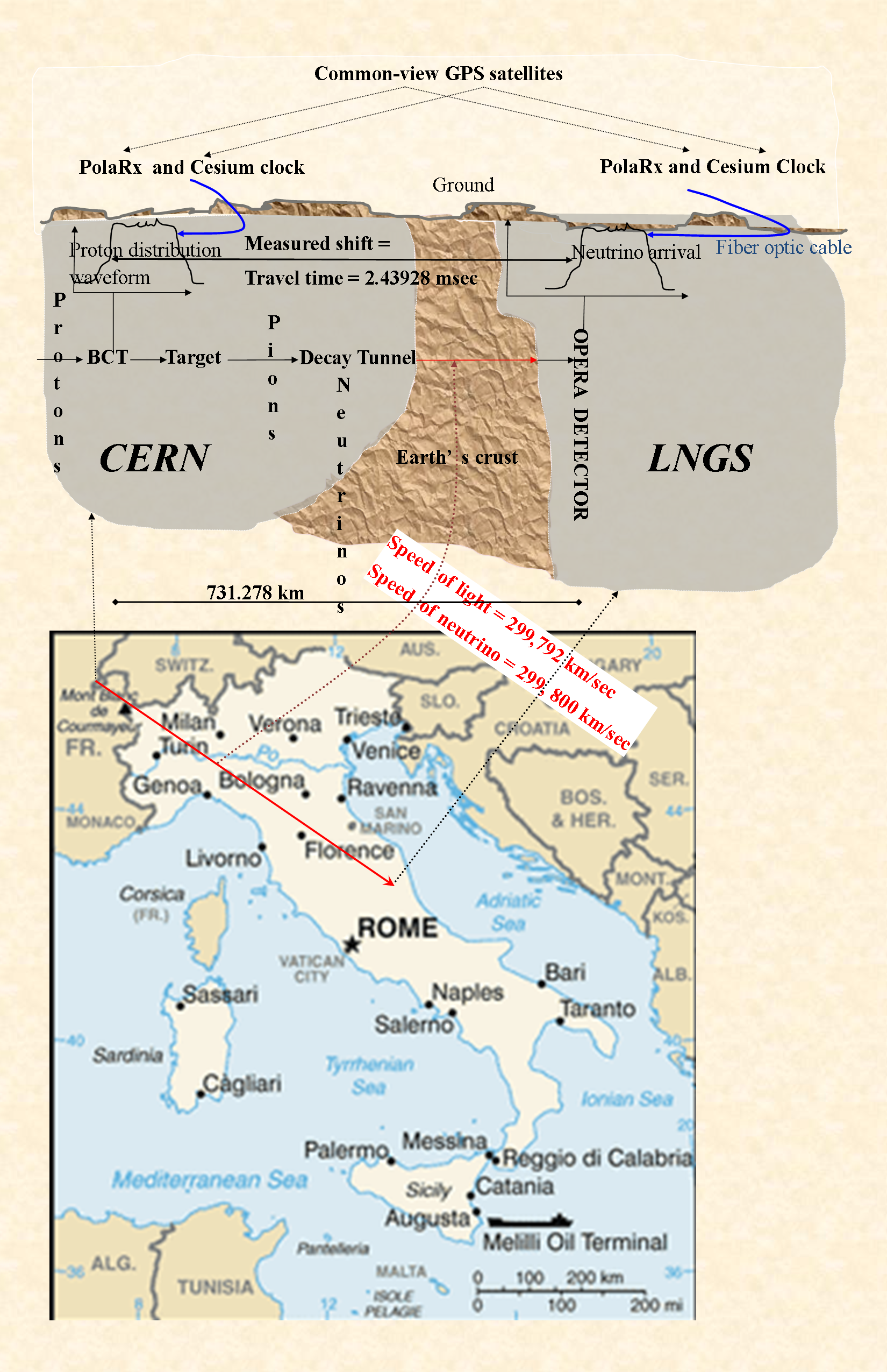
At https://www.cia.gov/about-cia/site-policies/index.html#copy archive copy at the Wayback Machine, the CIA explicitly marks all files-without-a-copyright-tag on its website as being in the public domain. This map has no tag. The top part is a description of the overall system used by the OPERA experiment. See arXiv eprint 1109.4897, Figure 5. (https://arxiv.org/abs/1109.4897). While this figure is based on that one, nothing has been copied from there - this was drawn from scratch on Microsoft Publisher. Source file is also public domain, and will be provided on request.
File history
Click on a date/time to view the file as it appeared at that time.
| Date/Time | Thumbnail | Dimensions | User | Comment | |
|---|---|---|---|---|---|
| current | 19:35, 31 December 2011 | | 1,650 × 2,550 (2.29 MB) | Ajoykt~commonswiki (talk | contribs) | Parchment background. Stamp the whole figure with the final result, not just the map. |
| 23:41, 28 December 2011 |  | 1,650 × 2,550 (1.7 MB) | Ajoykt~commonswiki (talk | contribs) | a more sober version. Also, get location of CERN right. | |
| 21:20, 28 December 2011 |  | 1,650 × 2,550 (1.72 MB) | Ajoykt~commonswiki (talk | contribs) | Accurate distance and time measurements. | |
| 17:35, 28 December 2011 |  | 1,650 × 2,550 (1.72 MB) | Ajoykt~commonswiki (talk | contribs) | Touchups (would like to delete older versions - no point keeping them around - how do I do it?) | |
| 17:34, 28 December 2011 |  | 1,650 × 2,550 (982 KB) | Ajoykt~commonswiki (talk | contribs) | Reverted to version as of 23:44, 26 December 2011 | |
| 17:30, 28 December 2011 |  | 1,650 × 2,550 (1.72 MB) | Ajoykt~commonswiki (talk | contribs) | Minor touchups. | |
| 17:21, 28 December 2011 |  | 1,650 × 2,550 (1.72 MB) | Ajoykt~commonswiki (talk | contribs) | Make the map, and the earth's crust, a bit bigger. Highlight result more clearly. | |
| 00:24, 28 December 2011 |  | 1,650 × 2,550 (1.19 MB) | Ajoykt~commonswiki (talk | contribs) | Minor edit to make "art text" clearer to see. Some font-size changes. | |
| 18:15, 27 December 2011 |  | 1,650 × 2,550 (1.16 MB) | Ajoykt~commonswiki (talk | contribs) | Minor edits to connector overlap and direction of arrows. | |
| 17:45, 27 December 2011 |  | 1,650 × 2,550 (1.16 MB) | Ajoykt~commonswiki (talk | contribs) | Increase text-font size; take out boxes around text. In general,see if image can be made readable at smaller size. |
You cannot overwrite this file.
File usage on Commons
There are no pages that use this file.
File usage on other wikis
The following other wikis use this file:
- Usage on en.wikipedia.org
- Usage on es.wikipedia.org
- Usage on ru.wikipedia.org