File:Tortuosity via geodesic distance calculation.tif
Jump to navigation
Jump to search

Size of this JPG preview of this TIF file: 678 × 600 pixels. Other resolutions: 271 × 240 pixels | 543 × 480 pixels | 869 × 768 pixels | 1,158 × 1,024 pixels | 2,316 × 2,048 pixels | 2,714 × 2,400 pixels.
Original file (2,714 × 2,400 pixels, file size: 7.06 MB, MIME type: image/tiff)
Captions
Captions
Add a one-line explanation of what this file represents
Summary
[edit]| Description |
English: Geodesic distance calculated within the pore space of a sandstone, imaged by x-ray microtomography. The geodesic distance is the length of the shortest paths between two points witing the pore space. The ratio of the geodesic distance to the straight-line distance is the tortuosity |
| Date | |
| Source | Own work |
| Author | Cedric J Gommes |
Licensing
[edit]I, the copyright holder of this work, hereby publish it under the following license:
This file is licensed under the Creative Commons Attribution-Share Alike 3.0 Unported license.
- You are free:
- to share – to copy, distribute and transmit the work
- to remix – to adapt the work
- Under the following conditions:
- attribution – You must give appropriate credit, provide a link to the license, and indicate if changes were made. You may do so in any reasonable manner, but not in any way that suggests the licensor endorses you or your use.
- share alike – If you remix, transform, or build upon the material, you must distribute your contributions under the same or compatible license as the original.
File history
Click on a date/time to view the file as it appeared at that time.
| Date/Time | Thumbnail | Dimensions | User | Comment | |
|---|---|---|---|---|---|
| current | 06:58, 15 April 2013 |  | 2,714 × 2,400 (7.06 MB) | Gommes (talk | contribs) | Lower resolution than the first one. |
| 05:41, 15 April 2013 | 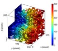 | 5,427 × 4,800 (21.1 MB) | Gommes (talk | contribs) | User created page with UploadWizard |
You cannot overwrite this file.
File usage on Commons
There are no pages that use this file.
File usage on other wikis
The following other wikis use this file:
- Usage on en.wikipedia.org
- Usage on fa.wikipedia.org