File:Topography of Mawrth Vallis ESA24991145.tiff
Jump to navigation
Jump to search

Size of this JPG preview of this TIF file: 800 × 202 pixels. Other resolutions: 320 × 81 pixels | 640 × 162 pixels | 1,024 × 259 pixels | 1,280 × 323 pixels | 2,560 × 647 pixels | 14,249 × 3,600 pixels.
Original file (14,249 × 3,600 pixels, file size: 126.42 MB, MIME type: image/tiff)
Captions
Captions
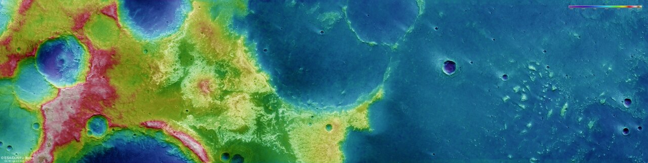
This colour-coded topographic image shows the Mawrth Vallis region of Mars. It was created from data collected by ESA’s Mars Express on 18 February 2023 during orbit 24164.
Summary
[edit]| Description |
English: This colour-coded topographic image shows the Mawrth Vallis region of Mars. It was created from data collected by ESA’s Mars Express on 18 February 2023 during orbit 24164. It is based on a digital terrain model of the region, from which the topography of the landscape can be derived. Lower parts of the surface are shown in blue tones, while higher altitude regions show up in yellows and reds, as indicated on the scale to the top right. North is to the right. The ground resolution is approximately 18 m/pixel and the image is centred at about 25°N/339°E. Read more |
| Date | 19 July 2023 (upload date) |
| Source | Topography of Mawrth Vallis |
| Author | ESA/DLR/FU Berlin |
| Other versions |
|
| Activity | Space Science |
| Mission | Mars Express |
Licensing
[edit]This media was created by the European Space Agency (ESA).
Where expressly so stated, images or videos are covered by the Creative Commons Attribution-ShareAlike 3.0 IGO (CC BY-SA 3.0 IGO) licence, ESA being an Intergovernmental Organisation (IGO), as defined by the CC BY-SA 3.0 IGO licence. The user is allowed under the terms and conditions of the CC BY-SA 3.0 IGO license to Reproduce, Distribute and Publicly Perform the ESA images and videos released under CC BY-SA 3.0 IGO licence and the Adaptations thereof, without further explicit permission being necessary, for as long as the user complies with the conditions and restrictions set forth in the CC BY-SA 3.0 IGO licence, these including that:
See the ESA Creative Commons copyright notice for complete information, and this article for additional details.
|
 | |
This file is licensed under the Creative Commons Attribution-ShareAlike 3.0 IGO license. Attribution: ESA/DLR/FU Berlin, CC BY-SA IGO 3.0
| ||
File history
Click on a date/time to view the file as it appeared at that time.
| Date/Time | Thumbnail | Dimensions | User | Comment | |
|---|---|---|---|---|---|
| current | 06:03, 20 July 2023 | 14,249 × 3,600 (126.42 MB) | OptimusPrimeBot (talk | contribs) | #Spacemedia - Upload of https://esamultimedia.esa.int/img/2023/07/o164_coldtm.tif via Commons:Spacemedia |
You cannot overwrite this file.
File usage on Commons
The following 2 pages use this file: