File:Topographic map of Gabon-de.svg
Jump to navigation
Jump to search

Size of this PNG preview of this SVG file: 506 × 599 pixels. Other resolutions: 203 × 240 pixels | 405 × 480 pixels | 649 × 768 pixels | 865 × 1,024 pixels | 1,730 × 2,048 pixels | 815 × 965 pixels.
Original file (SVG file, nominally 815 × 965 pixels, file size: 2.71 MB)
Captions
Captions
Add a one-line explanation of what this file represents
Summary
[edit]| Description |
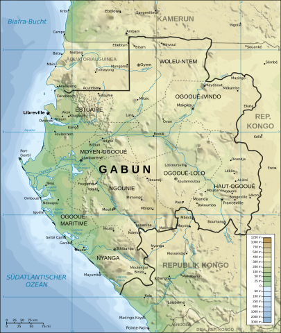
Deutsch: Topographische Karte von Gabun.
English: Topographic map of Gabon.
Suomi: Gabonin topograginen kartta.
Français : Carte topographique du Gabon.
Македонски: Карта на Фабон. |
||
| Date | |||
| Source |
This file was derived from: Topographic map of Gabon-en.svg by Mysid |
||
| Author | Mysid, German translation by Furfur | ||
| Permission (Reusing this file) |
I, the copyright holder of this work, hereby publish it under the following licenses:
This file is licensed under the Creative Commons Attribution-Share Alike 4.0 International license.
You may select the license of your choice. |
||
| Other versions |
[]
|
||
| SVG development |


File history
Click on a date/time to view the file as it appeared at that time.
| Date/Time | Thumbnail | Dimensions | User | Comment | |
|---|---|---|---|---|---|
| current | 11:35, 31 August 2023 | | 815 × 965 (2.71 MB) | Furfur (talk | contribs) | Detailkorrekturen |
| 14:01, 17 April 2021 |  | 815 × 965 (1.67 MB) | Furfur (talk | contribs) | == {{int:filedesc}} == {{Information |Description={{User:Medium69/Traduction}} {{de|1=Topographische Karte von Gabun.}} {{en|Topographic map of Gabon.}} {{fi|Gabonin topograginen kartta.}} {{fr|1=Carte topographique du Gabon.}} {{mk|Карта на Фабон.}} |Source={{Derived from|Topographic map of Gabon-en.svg|by=Mysid}} |Date=2021-04-17 |Author={{U|Mysid}}, German translation by {{U|Furfur}} |Permission={{self|GFDL|cc-by-sa-4.0}} |Other versions={{Other versions/Topograph... |
You cannot overwrite this file.
File usage on Commons
The following 9 pages use this file:
- User:Magog the Ogre/Multilingual legend/2021 April 11-20
- User:Magog the Ogre/Multilingual legend/2023 August 27-31
- File:Localisation de Lambaréné.jpg
- File:Topographic map of Gabon-de.svg
- File:Topographic map of Gabon-en.svg
- File:Topographic map of Gabon-fr.svg
- File:Topographic map of Gabon-mk.svg
- File:Topographic map of Gabon-sr.svg
- Template:Other versions/Topographic map of Gabon
File usage on other wikis
The following other wikis use this file:
- Usage on de.wikipedia.org