File:Topografische kaart Hoogeveen 1910.jpg
Topografische_kaart_Hoogeveen_1910.jpg (568 × 406 pixels, file size: 222 KB, MIME type: image/jpeg)
Captions
Captions
Summary
[edit]
| Description |
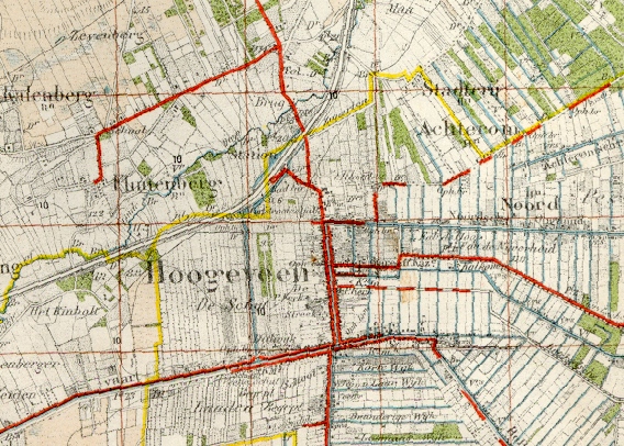
Nederlands: Fragment van een topografische kaart schaal 1:50.000 rond Hoogeveen. Dit is een gedeelte van de kaart Beilen nr. 17 uitgegeven in 1914. Auteursrechten voorbehouden aan de Staat der Nederlanden. De kaart is dus nu Publiek Domein vanwege ouderdom. |
| Date | |
| Source | Staat der Nederlanden |
| Author |
Roepers Original uploader was Nijeholt at nl.wikibooks |
| Permission (Reusing this file) |
PD-OUD. |
Licensing
[edit]
|
This work is in the public domain in its country of origin and other countries and areas where the copyright term is the author's life plus 70 years or fewer.
| |
| This file has been identified as being free of known restrictions under copyright law, including all related and neighboring rights. | |
Original upload log
[edit]
- 2007-11-22 19:15 Nijeholt 568×406× (227339 bytes) {{Information |Description=Fragment van een topografische kaart schaal 1:50.000 rond [[Hoogeveen]]. Dit is een gedeelte van de kaart Beilen nr. 17 uitgegeven in 1914. Auteursrechten voorbehouden aan de Staat der Nederlanden. De kaart is dus nu Publiek Dom
File history
Click on a date/time to view the file as it appeared at that time.
| Date/Time | Thumbnail | Dimensions | User | Comment | |
|---|---|---|---|---|---|
| current | 20:11, 4 March 2009 | | 568 × 406 (222 KB) | BotMultichill (talk | contribs) | {{BotMoveToCommons|nl.wikibooks|year={{subst:CURRENTYEAR}}|month={{subst:CURRENTMONTHNAME}}|day={{subst:CURRENTDAY}}}} {{Information |Description={{nl|Fragment van een topografische kaart schaal 1:50.000 rond Hoogeveen. Dit is een gedeelte van de kaart |
You cannot overwrite this file.
File usage on Commons
There are no pages that use this file.
File usage on other wikis
The following other wikis use this file:
- Usage on nl.wikipedia.org
- Usage on nl.wikibooks.org
- Usage on www.wikidata.org