<nowiki>Category:Maps of Hoogeveen; categoría de Wikimedia; kategori Wikimedia; Wikimedia category; د ويکيمېډيا وېشنيزه; Vikimedya kategorisi; ویکیمیڈیا زمرہ; kategória projektov Wikimedia; категорія проєкту Вікімедіа; 维基媒体分类; Wikimedia-Kategorie; Викимедиина категорија; kategorija na Wikimediji; विकिपीडिया:श्रेणी; page de catégorie de Wikimedia; kategorija na Wikimediji; विकिपीडिया वर्ग; категорија на Викимедији; Wikimedia-Kategorie; Wikimedia-kategori; kategori Wikimédia; تصنيف ويكيميديا; pajenn rummata eus Wikimedia; Wikimedia:ကဏ္ဍခွဲခြင်း; 維基媒體分類; Wikimedia категориясы; categoría de Wikimedia; categoria de Wikimedia; Wikimedia-Kategorie; tudalen categori Wikimedia; kategori e Wikimedias; ردهٔ ویکیپدیا; 维基媒体分类; Wikimedia-kategory; ვიკიპედია:კატეგორიზაცია; ウィキメディアのカテゴリ; categoria Wikimedia; تصنيف بتاع ويكيميديا; විකිමීඩියා ප්රභේද පිටුව; categoria Vicimediorum; विकिमीडिया श्रेणी; Wikimedia-luokka; Wikimedia category; guruhi Vikimedia; катэгорыя ў праекце Вікімэдыя; Викимедиа проектындагы төркем; catigurìa di nu pruggettu Wikimedia; หน้าหมวดหมู่วิกิมีเดีย; Wikimedia:Kategorija; Wikimedia-Kategorie; Wikimedia:Klassys; категория на Уикимедия; categorie a unui proiect Wikimedia; 維基媒體分類; Wikimedia-kategori; kawan Wikimèdia; гурӯҳи Викимедиа; 위키미디어 분류; Wikimedia-bólkur; kategorio en Vikimedio; kategori Wikimedia; Wikimedia:Ronnaghys; উইকিমিডিয়া বিষয়শ্রেণী; kategori Wikimedia; 维基媒体分类; וויקימעדיע קאַטעגאָריע; kategorija w projektach Wikimedije; thể loại Wikimedia; Wikimedia projekta kategorija; Wikimedia-kategorie; categoria de um projeto da Wikimedia; 维基媒体分类; категорияд Ангилал; Wikimedia-kategori; kategori Wikimedia; پۆلی ویکیمیدیا; Wikimedia category; Vikimédia ñemohenda; Wikimédia-kategória; વિકિપીડિયા શ્રેણી; Wikimediako kategoria; категория в проекте Викимедиа; Wikimedia-Kategorie; катэгорыя ў праекце Вікімедыя; Wikimedia-kategorie; Wîkîmediya:Kategorî; विकिमिडिया श्रेणी; Wikimedia-Kategorie; קטגוריה במיזמי ויקימדיה; Викимедиа проектындагы төркем; 維基媒體分類; विकिमिडिया श्रेणी; κατηγορία εγχειρημάτων Wikimedia; Wikimedia-kategoriija; гурӯҳи Викимедиа; Wikimedia-Kategorie; categoría de Wikimedia; Wikimedia-categorie; categoria di un progetto Wikimedia; விக்கிமீடியப் பகுப்பு; jamii ya Wikimedia; Wikimedia category; Wikimedia kategooria; categurìa 'e nu pruggette Wikimedia; Wikimedia-categorie; Wikimedia-kategori; kategorya ng Wikimedia; ẹ̀ka Wikimedia; 維基媒體分類; categoria de um projeto da Wikimedia; kategorie na projektech Wikimedia; Wikimedia-Kategorie; tumbung Wikimedia; Վիքիմեդիայի նախագծի կատեգորիա; kategorija Wikimedie; Wikimedia proyektındağı törkem; kategoria ti Wikimedia; Викимедиа категорияһы; kategori Wikimedia; kategoria w projekcie Wikimedia; വിക്കിമീഡിയ വർഗ്ഗം; Wikimedia-categorie; kategori Wikimedia; Viciméid catagóir; زمرو:وڪيپيڊيا زمرا بندي; 維基媒體分類; categoría de Wikimedia; Vikipidiya:Shopni; 维基媒体分类; Kategoriya ning Wikimedia</nowiki>
Subcategories
This category has only the following subcategory.


.png)

 Map - NL - Municipality code 0118 (2009).svg 300 × 160; 530 KB
 2013-Hoogeveen.jpg 3,002 × 2,952; 4.43 MB
 BAG woonplaatsen - Gemeente Hoogeveen.png 2,419 × 2,419; 734 KB
 E 233 Hoogeveen-Cloppenburg.png 1,096 × 378; 21 KB
 Gem-Hoogeveen-2014Q1.jpg 5,802 × 5,894; 12.03 MB
 Gem-Hoogeveen-OpenTopo.jpg 5,495 × 5,712; 3.55 MB
 Hoogeveen 6.48182E 52.72893N.jpg 1,280 × 958; 176 KB
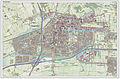 Hoogeveen-plaats-OpenTopo.jpg 2,562 × 1,691; 2.24 MB
 Hoogeveen-stad-2014Q1.jpg 2,562 × 1,691; 2.16 MB
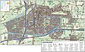 Hoogeveen-topografie.jpg 1,904 × 1,163; 1.43 MB
 Kadastale minuutplan Hoogeveen, Drenthe, sectie A, blad 02.jpg 11,640 × 7,904; 16.24 MB
 Locatie Nieuwlande.png 280 × 130; 7 KB
 Map - NL - Hoogeveen (2009).svg 625 × 575; 1.52 MB
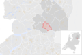 NL - locator map municipality code GM0118 (2016).png 2,125 × 1,417; 426 KB
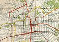 Topografische kaart Hoogeveen 1910.jpg 568 × 406; 222 KB
 Tramlijn Hoogeveen - Nieuw-Amsterdam.png 1,394 × 1,037; 1.76 MB
.svg)


.svg)

