File:TontoNatlMnmt L7 15jun00.jpg
Jump to navigation
Jump to search
No higher resolution available.
TontoNatlMnmt_L7_15jun00.jpg (540 × 540 pixels, file size: 115 KB, MIME type: image/jpeg)
Captions
Captions
Add a one-line explanation of what this file represents
Summary
[edit]
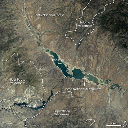
| Description |
English: Satellite image of w:Tonto National Monument and the surrounding area, including Roosevelt Lake and Apache Lake reservoirs of the Salt River Project. |
| Date | |
| Source | http://earthobservatory.nasa.gov/Newsroom/NewImages/images.php3?img_id=17021 |
| Author | Jesse Allen, NASA Earth Observatory, using data obtained courtesy of the University of Maryland’s Global Land Cover Facility. |
| Permission (Reusing this file) |
Public domain. |
| Other versions | Larger, uncropped, unannotated version available at source URL. |
Licensing
[edit]
| This file is in the public domain in the United States because it was solely created by NASA. NASA copyright policy states that "NASA material is not protected by copyright unless noted". (See Template:PD-USGov, NASA copyright policy page or JPL Image Use Policy.) | ||
 |
Warnings:
|
File history
Click on a date/time to view the file as it appeared at that time.
| Date/Time | Thumbnail | Dimensions | User | Comment | |
|---|---|---|---|---|---|
| current | 00:12, 6 May 2006 | | 540 × 540 (115 KB) | Holly Cheng (talk | contribs) | {{Information | Description=Satellite image of w:Tonto National Monument and the surrounding area, including Roosevelt Lake and w:Apache Lake. | Source=http://earthobservatory.nasa.gov/Newsroom/NewImages/images.php3?img_id |
You cannot overwrite this file.
File usage on Commons
There are no pages that use this file.
File usage on other wikis
The following other wikis use this file:
- Usage on en.wikipedia.org
- Usage on es.wikipedia.org
- Usage on nl.wikipedia.org
- Usage on ru.wikipedia.org
Metadata
Categories:
- Satellite pictures of Arizona
- Geography of Gila County, Arizona
- Salt River Project
- Theodore Roosevelt Lake
- Apache Lake (Arizona)
- Arizona transition zone mountain ranges
- Four Peaks
- Mazatzal Mountains
- Landsat images of the United States
- Maps of Gila County, Arizona
- Satellite pictures of lakes
- Tonto National Monument
- Maps of Tonto National Forest