File:Toba Port Map.png
Jump to navigation
Jump to search
Size of this preview: 392 × 600 pixels. Other resolutions: 157 × 240 pixels | 477 × 730 pixels.
Original file (477 × 730 pixels, file size: 22 KB, MIME type: image/png)
Captions
Captions
Add a one-line explanation of what this file represents
Summary
[edit]
| Description |
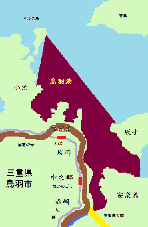
English: This is the map of the port of Toba(Mie,Japan).
日本語:三重県の鳥羽港の地図。赤紫色の部分が鳥羽港である。 |
| Date | |
| Source | Own work |
| Author | Miyuki Meinaka |
| Permission (Reusing this file) |
Public domain |
| Other versions | Nothing |
Iseshima national park
Licensing
[edit]
| I, the copyright holder of this work, release this work into the public domain. This applies worldwide. In some countries this may not be legally possible; if so: I grant anyone the right to use this work for any purpose, without any conditions, unless such conditions are required by law. |
File history
Click on a date/time to view the file as it appeared at that time.
| Date/Time | Thumbnail | Dimensions | User | Comment | |
|---|---|---|---|---|---|
| current | 02:56, 5 May 2009 | | 477 × 730 (22 KB) | Miyuki Meinaka (talk | contribs) | Minor Edit. |
| 02:52, 5 May 2009 |  | 477 × 730 (22 KB) | Miyuki Meinaka (talk | contribs) | {{Information |Description={{en|1=This is the map of the port of Toba(Mie,Japan).}} {{ja|1=三重県の鳥羽港の地図。赤紫色の部分が鳥羽港である。}} |Source=Own work by uploader |Author=Miyuki Meinaka |Date=May |
You cannot overwrite this file.
File usage on Commons
The following page uses this file: