File:To the Honorable Thomas Penn and Richard Penn, Esquires, true and absolute proprietaries and Governors of the Province of Pennsylvania and the territories thereunto belonging and to the NYPL434613.tiff
Jump to navigation
Jump to search

Size of this JPG preview of this TIF file: 800 × 590 pixels. Other resolutions: 320 × 236 pixels | 640 × 472 pixels | 1,024 × 755 pixels | 1,280 × 943 pixels | 2,560 × 1,886 pixels | 5,819 × 4,288 pixels.
Original file (5,819 × 4,288 pixels, file size: 71.43 MB, MIME type: image/tiff)
Captions
Captions
Add a one-line explanation of what this file represents
Summary
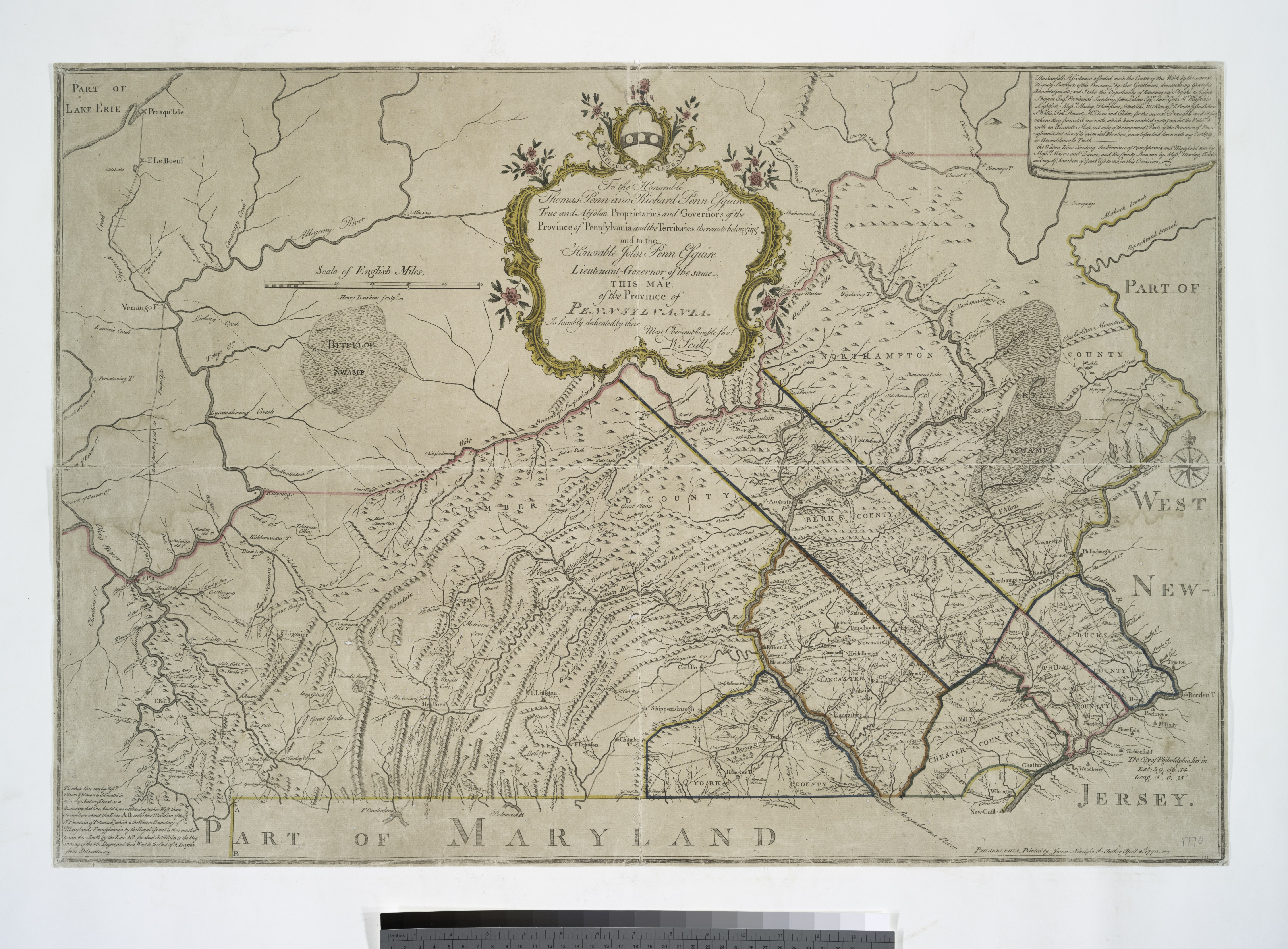
[edit]| Description | To the Honorable Thomas Penn and Richard Penn, Esquires, true and absolute proprietaries and Governors of the Province of Pennsylvania and the territories thereunto belonging and to the Honorable John Penn, Esquire, Lieutenant-Governor of the same, this map, of the Province of Pennsylvania is humbly dedicated by their most obedient servt. W. Scull / Printed by James Nevil, for the Author [W. Scull]; Henry Dawkins, sculpt.; Maps of North America. / Countries / United States (except New York) / States / Pennsylvania / Whole | |||||||||||||||||||||||
| Notes | National Endowment for the Humanities Grant for Access to Early Maps of the Middle Atlantic Seaboard. ''Note 2.'') Relief shown pictorially. ''Note 3.'') Shows county boundaries. ''Note 4.'') Includes decorative cartouche and notes. ''Note 5.'') Includes decorative cartouche and notes. ''Note 6.'') Includes decorative cartouche and notes. ''Note 7.'') Includes decorative cartouche and notes. | |||||||||||||||||||||||
| Item physical description | 1 map : hand col. ; 55 x 80 cm. | |||||||||||||||||||||||
| Catalogue call number | Map Div. 00-399 | |||||||||||||||||||||||
| Standard reference | Phillips. Maps of America, p. 674 | |||||||||||||||||||||||
| Date | April 4st sic, 1770 | |||||||||||||||||||||||
| Source |
http://digitalgallery.nypl.org/nypldigital/dgkeysearchdetail.cfm?imageID=434613
|
|||||||||||||||||||||||
| Author | William, fl. 1765 -- Surveyor Scull | |||||||||||||||||||||||
| Permission (Reusing this file) |
From The Lionel Pincus and Princess Firyal Map Division. http://maps.nypl.org
|
|||||||||||||||||||||||
| Location | Stephen A. Schwarzman Building / The Lionel Pincus and Princess Firyal Map Division | |||||||||||||||||||||||
| Digital item published | 2-3-2004; updated 3-25-2011 | |||||||||||||||||||||||
| Digital ID | 434613 | |||||||||||||||||||||||

The making of this file was supported by Wikimedia UK.
To see other files made with the support of Wikimedia UK, please see the category Supported by Wikimedia UK.
|
File history
Click on a date/time to view the file as it appeared at that time.
| Date/Time | Thumbnail | Dimensions | User | Comment | |
|---|---|---|---|---|---|
| current | 03:04, 14 April 2016 |  | 5,819 × 4,288 (71.43 MB) | SteinsplitterBot (talk | contribs) | Bot: Image rotated by 270° |
| 13:36, 7 May 2014 |  | 4,288 × 5,819 (71.39 MB) | Fæ (talk | contribs) | GWToolset: Creating mediafile for Fæ. Tranche 4 -4989 restart @08:55 BST, 7 May 2014 |
You cannot overwrite this file.
File usage on Commons
There are no pages that use this file.