File:Thurston Island - en.svg
Jump to navigation
Jump to search

Size of this PNG preview of this SVG file: 800 × 454 pixels. Other resolutions: 320 × 182 pixels | 640 × 363 pixels | 1,024 × 581 pixels | 1,280 × 727 pixels | 2,560 × 1,454 pixels | 2,328 × 1,322 pixels.
Original file (SVG file, nominally 2,328 × 1,322 pixels, file size: 278 KB)
Captions
Captions
Add a one-line explanation of what this file represents
This W3C-unspecified vector image was created with Inkscape .
W3C-validity not checked.
Summary
[edit]| Description |
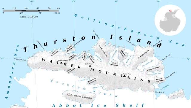
English: Thurston Island map. Русский: Карта антарктического острова Терстон. |
||
| Date | |||
| Source |
Own work
Topographic map : ETOPO 1 (public domain) edited with Quantum GIS+GeoCart and vectorized with Inkscape; Lambert equal-area projection ; shaded relief; |
||
| Author | Kaidor | ||
| Permission (Reusing this file) |
I, the copyright holder of this work, hereby publish it under the following licenses: This file is licensed under the Creative Commons Attribution-Share Alike 3.0 Unported license.
You may select the license of your choice. |
||
| Other versions | Template:Thurston Island - ru.svg |

| Camera location | | View this and other nearby images on: OpenStreetMap |
|---|

|
This SVG file contains embedded text that can be translated into your language, using any capable SVG editor, text editor or the SVG Translate tool. For more information see: About translating SVG files. |
File history
Click on a date/time to view the file as it appeared at that time.
| Date/Time | Thumbnail | Dimensions | User | Comment | |
|---|---|---|---|---|---|
| current | 16:33, 25 July 2022 | | 2,328 × 1,322 (278 KB) | Like tears in rain (talk | contribs) | File uploaded using svgtranslate tool (https://svgtranslate.toolforge.org/). Added translation for fr. |
| 14:04, 2 May 2019 |  | 2,328 × 1,322 (257 KB) | Kaidor (talk | contribs) | Ocaen → Seas | |
| 22:38, 2 July 2013 |  | 2,328 × 1,322 (242 KB) | Kaidor (talk | contribs) | Замена текста Thursten → Thusrton | |
| 22:10, 2 July 2013 |  | 2,328 × 1,322 (236 KB) | Kaidor (talk | contribs) | Более светлый рельеф | |
| 22:01, 2 July 2013 |  | 2,328 × 1,322 (240 KB) | Kaidor (talk | contribs) | User created page with UploadWizard |
You cannot overwrite this file.
File usage on Commons
The following 6 pages use this file:
File usage on other wikis
The following other wikis use this file:
- Usage on af.wikipedia.org
- Usage on bg.wikipedia.org
- Usage on ceb.wikipedia.org
- Sherman Island (pulo sa Antartika)
- Myers Glacier
- Parker Peak (tumoy sa bukid sa Antartika, lat -72,30, long -97,40)
- Pelter Glacier
- Savage Glacier
- Sikorski Glacier
- Simpson (bukid)
- Smith Peak (tumoy sa bukid sa Antartika)
- Walker Mountains
- Bearman Glacier
- Bellisime Glacier
- Bulbur Glacier
- Foley Glacier (suba sa yelo sa Antartika)
- Goff Glacier
- Hlubeck Glacier
- Isbrecht Glacier
- Levko Glacier
- Litz Glacier
- Mahaffey Glacier
- Marck Glacier
- Mincer Glacier
- Payne Glacier
- Rexford Glacier
- Rignot Glacier
- Robbins Glacier
- Rosanova Glacier
- Sessums Glacier
- Warr Glacier
- Zinberg Glacier
- Craft Glacier
- Deadmond Glacier
- Dustin Island (pulo sa Antartika)
- Flying Fish
- Frankenfield Glacier
- Hale Glacier
- Kannheiser Glacier
- Long Glacier (suba sa yelo sa Antartika)
- Mulroy Island
- Usage on cs.wikipedia.org
- Usage on de.wikipedia.org
View more global usage of this file.