File:Thorn, Horn, Kessenich.PNG
Jump to navigation
Jump to search
No higher resolution available.
Thorn,_Horn,_Kessenich.PNG (589 × 560 pixels, file size: 182 KB, MIME type: image/png)
Captions
Captions
Add a one-line explanation of what this file represents
Summary
[edit]
| Description |
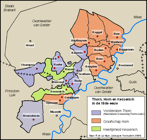
English: Map of the principalities Thorn, Horn and Kessenich around 1700. Adaptation of map in Régis de La Haye, "Limburgse voorouders" (1994), p. 86. |
| Date | |
| Source | Genwiki Limburg |
| Author | Mart Graef |
Licensing
[edit]
| I, the copyright holder of this work, release this work into the public domain. This applies worldwide. In some countries this may not be legally possible; if so: I grant anyone the right to use this work for any purpose, without any conditions, unless such conditions are required by law. |
File history
Click on a date/time to view the file as it appeared at that time.
| Date/Time | Thumbnail | Dimensions | User | Comment | |
|---|---|---|---|---|---|
| current | 10:38, 4 October 2009 | | 589 × 560 (182 KB) | MWMG (talk | contribs) | {{Information |Description={{en|1=Map of the principalities Thorn, Horn and Kessenich in the 18th century. Adaptation of map in Régis de La Haye, "Limburgse voorouders" (1994), p. 86.}} |Source=Genwiki Limburg; http://genwiki.nl/limburg/index.php?title=A |
You cannot overwrite this file.
File usage on Commons
The following page uses this file:
File usage on other wikis
The following other wikis use this file:
- Usage on ar.wikipedia.org
- Usage on bg.wikipedia.org
- Usage on de.wikipedia.org
- Usage on en.wikipedia.org
- Usage on li.wikipedia.org
- Usage on nl.wikipedia.org
- Usage on sl.wikipedia.org