File:Thonburi-history-map.png
Jump to navigation
Jump to search
Size of this preview: 426 × 599 pixels. Other resolutions: 171 × 240 pixels | 480 × 675 pixels.
Original file (480 × 675 pixels, file size: 58 KB, MIME type: image/png)
Captions
Captions
Add a one-line explanation of what this file represents
Summary
[edit]
| Description |
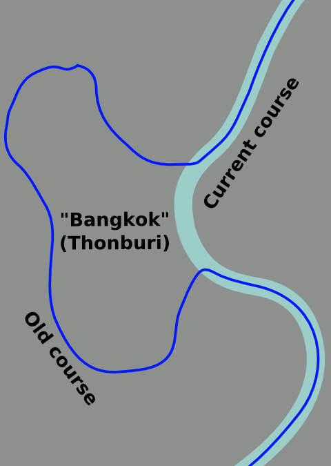
English: Current and historic course of the Chao Phraya River in Bangkok. |
| Date | |
| Source | Own work based on OpenStreetMap.org [1]. |
| Author | Globe-trotter |
| Other versions | Thonburi-history-map.svg |
Licensing
[edit]
This file is licensed under the Creative Commons Attribution-Share Alike 3.0 Unported license.
- You are free:
- to share – to copy, distribute and transmit the work
- to remix – to adapt the work
- Under the following conditions:
- attribution – You must give appropriate credit, provide a link to the license, and indicate if changes were made. You may do so in any reasonable manner, but not in any way that suggests the licensor endorses you or your use.
- share alike – If you remix, transform, or build upon the material, you must distribute your contributions under the same or compatible license as the original.
Original upload log
[edit]
| This file was imported from Wikivoyage WTS. |
The original description page was here. All following user names refer to wts.wikivoyage-old.
- 2010-10-23 03:08 (WT-shared) Globe-trotter[dead link] 480×675 (42563 bytes) {{Imagecredit|credit=Globe-trotter, based on data from OpenStreetMap.org [http://openstreetmap.org]|captureDate=October 23, 2010|location=Ba (Import from wikitravel.org/shared)
- 2011-07-08 21:49 (WT-shared) Globe-trotter[dead link] 480×675 (59093 bytes) made both blue (so they are both seen as rivers), and added text to make it clearer (Import from wikitravel.org/shared)
- 2012-01-18 15:52 (WT-shared) Globe-trotter[dead link] 480×675 (59227 bytes) updated name Bangkok (Import from wikitravel.org/shared)
File history
Click on a date/time to view the file as it appeared at that time.
| Date/Time | Thumbnail | Dimensions | User | Comment | |
|---|---|---|---|---|---|
| current | 04:29, 18 December 2012 | | 480 × 675 (58 KB) | OgreBot (talk | contribs) | (BOT): Reverting to most recent version before archival |
| 04:29, 18 December 2012 |  | 480 × 675 (58 KB) | OgreBot (talk | contribs) | (BOT): Uploading old version of file from wts.wikivoyage; originally uploaded on 2011-07-08 21:49:59 by (WT-shared) Globe-trotter | |
| 04:28, 18 December 2012 |  | 480 × 675 (42 KB) | OgreBot (talk | contribs) | (BOT): Uploading old version of file from wts.wikivoyage; originally uploaded on 2010-10-23 03:08:47 by (WT-shared) Globe-trotter | |
| 03:03, 18 November 2012 |  | 480 × 675 (58 KB) | MGA73bot2 (talk | contribs) | {{BotMoveToCommons|wts.oldwikivoyage|year={{subst:CURRENTYEAR}}|month={{subst:CURRENTMONTHNAME}}|day={{subst:CURRENTDAY}}}} == {{int:filedesc}} == {{Information |description=Current and historic course of the Chao Phraya River in Bangkok. * Map of: Ban... |
You cannot overwrite this file.
File usage on Commons
There are no pages that use this file.
File usage on other wikis
The following other wikis use this file:
- Usage on en.wikivoyage.org