File:The United States and the relative position of the Oregon and Texas - by James Wyld, Charing Cross East. NYPL434837.tiff
Jump to navigation
Jump to search

Size of this JPG preview of this TIF file: 499 × 600 pixels. Other resolutions: 200 × 240 pixels | 399 × 480 pixels | 639 × 768 pixels | 852 × 1,024 pixels | 1,704 × 2,048 pixels | 4,936 × 5,931 pixels.
Original file (4,936 × 5,931 pixels, file size: 83.76 MB, MIME type: image/tiff)
Captions
Captions
Add a one-line explanation of what this file represents
Summary
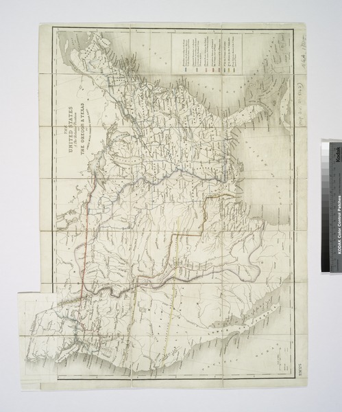
[edit]| Description | The United States and the relative position of the Oregon and Texas / by James Wyld, Charing Cross East.; Maps of North America. / Countries / United States (except New York) / Whole | |||||||||||||||||||||||
| Notes | National Endowment for the Humanities Grant for Access to Early Maps of the Middle Atlantic Seaboard. ''Note 2.'') Relief shown by hachures. ''Note 3.'') Slip pasted at top of map to show the boundary line of the 1824 treaty between Russia and the U.S. and at right edge to describe seven other boundaries indicated on map by color lines. NN | |||||||||||||||||||||||
| Item physical description | 1 map : hand col. ; 43 x 54 cm. | |||||||||||||||||||||||
| Catalogue call number | Map Div. 01-5142 | |||||||||||||||||||||||
| Standard reference | Wheat, C.I. Mapping the transmississippi West, II, 503 | |||||||||||||||||||||||
| Date | ||||||||||||||||||||||||
| Source |
http://digitalgallery.nypl.org/nypldigital/dgkeysearchdetail.cfm?imageID=434837
|
|||||||||||||||||||||||
| Author | James, 1812-1887 -- Geographer (not in Relator list) Wyld | |||||||||||||||||||||||
| Permission (Reusing this file) |
From The Lionel Pincus and Princess Firyal Map Division. http://maps.nypl.org
|
|||||||||||||||||||||||
| Location | Stephen A. Schwarzman Building / The Lionel Pincus and Princess Firyal Map Division | |||||||||||||||||||||||
| Digital item published | 2-3-2004; updated 3-25-2011 | |||||||||||||||||||||||
| Digital ID | 434837 | |||||||||||||||||||||||

The making of this file was supported by Wikimedia UK.
To see other files made with the support of Wikimedia UK, please see the category Supported by Wikimedia UK.
|
File history
Click on a date/time to view the file as it appeared at that time.
| Date/Time | Thumbnail | Dimensions | User | Comment | |
|---|---|---|---|---|---|
| current | 15:21, 7 May 2014 |  | 4,936 × 5,931 (83.76 MB) | Fæ (talk | contribs) | GWToolset: Creating mediafile for Fæ. Tranche 4 -4989 restart @08:55 BST, 7 May 2014 |
You cannot overwrite this file.
File usage on Commons
There are no pages that use this file.