File:The Crescent, Buxton - geograph.org.uk - 1354937.jpg
Jump to navigation
Jump to search
No higher resolution available.
The_Crescent,_Buxton_-_geograph.org.uk_-_1354937.jpg (640 × 480 pixels, file size: 71 KB, MIME type: image/jpeg)
Captions
Captions
Add a one-line explanation of what this file represents
Summary
[edit]
| Description |
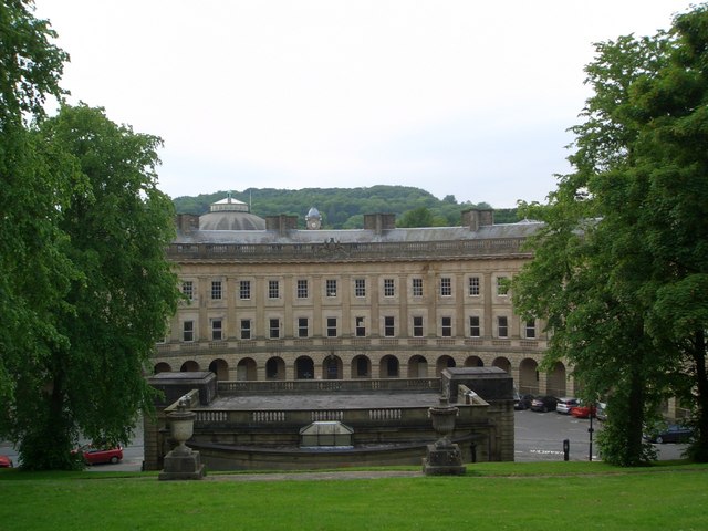
English: The Crescent, Buxton Designed in the 1770s by John Carr of York, to rival Bath. It was originally two hotels and six boarding houses. Eventually the hotels took over the whole block but the building became derelict in the 1980s and is about to be transformed into one, new, spa hotel utilising the hot springs which were once sampled in the former pumphouse in the foreground.
Beyond is the dome of the Royal Devonshire Hospital, originally the stable block for the hotels and now part of the University of Derby. |
| Date | |
| Source | From geograph.org.uk |
| Author | Gareth Hughes |
| Attribution (required by the license) | Gareth Hughes / The Crescent, Buxton / |
| Camera location | | View this and other nearby images on: OpenStreetMap |
|---|
_heading:337.00&language=en)
| Object location | | View this and other nearby images on: OpenStreetMap |
|---|
_heading:337.00&language=en)
Licensing
[edit]

|
This image was taken from the Geograph project collection. See this photograph's page on the Geograph website for the photographer's contact details. The copyright on this image is owned by Gareth Hughes and is licensed for reuse under the Creative Commons Attribution-ShareAlike 2.0 license.
|
This file is licensed under the Creative Commons Attribution-Share Alike 2.0 Generic license.
Attribution: Gareth Hughes
- You are free:
- to share – to copy, distribute and transmit the work
- to remix – to adapt the work
- Under the following conditions:
- attribution – You must give appropriate credit, provide a link to the license, and indicate if changes were made. You may do so in any reasonable manner, but not in any way that suggests the licensor endorses you or your use.
- share alike – If you remix, transform, or build upon the material, you must distribute your contributions under the same or compatible license as the original.
File history
Click on a date/time to view the file as it appeared at that time.
| Date/Time | Thumbnail | Dimensions | User | Comment | |
|---|---|---|---|---|---|
| current | 09:05, 28 February 2011 | | 640 × 480 (71 KB) | GeographBot (talk | contribs) | == {{int:filedesc}} == {{Information |description={{en|1=The Crescent, Buxton Designed in the 1770s by John Carr of York, to rival Bath. It was originally two hotels and six boarding houses. Eventually the hotels took over the whole block but the building |
You cannot overwrite this file.
File usage on Commons
There are no pages that use this file.