File:Territory Of The German Military Commander In Serbia 1941-44.png
Jump to navigation
Jump to search
Size of this preview: 474 × 599 pixels. Other resolutions: 190 × 240 pixels | 500 × 632 pixels.
Original file (500 × 632 pixels, file size: 99 KB, MIME type: image/png)
Captions
Captions
Add a one-line explanation of what this file represents
Summary
[edit]
| Description |
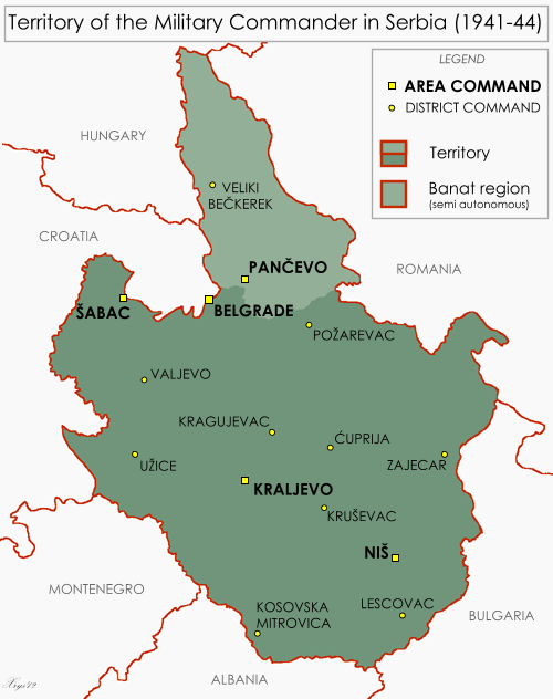
English: Map of the Territory of the German Military Commander in Serbia. Showing area and district commands and the Banat autonomous region. |
| Date | |
| Source | Own work, drawn from Serbia - June 1944 1:2M MDR Misc 8380, Survey Directorate, Middle East (1944) and Volkstumkarte Jugoslawien 1:200k, Wilfried Krallert, Publikationsstelle Wien (1941) |
| Author | XrysD |
Licensing
[edit]
I, the copyright holder of this work, hereby publish it under the following license:
This file is licensed under the Creative Commons Attribution-Share Alike 3.0 Unported license.
- You are free:
- to share – to copy, distribute and transmit the work
- to remix – to adapt the work
- Under the following conditions:
- attribution – You must give appropriate credit, provide a link to the license, and indicate if changes were made. You may do so in any reasonable manner, but not in any way that suggests the licensor endorses you or your use.
- share alike – If you remix, transform, or build upon the material, you must distribute your contributions under the same or compatible license as the original.
File history
Click on a date/time to view the file as it appeared at that time.
| Date/Time | Thumbnail | Dimensions | User | Comment | |
|---|---|---|---|---|---|
| current | 13:47, 10 May 2012 | | 500 × 632 (99 KB) | XrysD (talk | contribs) | Removed map frame as infobox border now acts as frame |
| 19:59, 9 May 2012 |  | 500 × 632 (94 KB) | XrysD (talk | contribs) | Border colour now AAAAAA to fit with Infobox template | |
| 19:29, 9 May 2012 |  | 500 × 632 (94 KB) | XrysD (talk | contribs) | Reverted to version as of 19:19, 9 May 2012 | |
| 19:22, 9 May 2012 |  | 500 × 632 (117 KB) | XrysD (talk | contribs) | Border colour now matches AAAAAA of Infobox style | |
| 19:19, 9 May 2012 |  | 500 × 632 (94 KB) | XrysD (talk | contribs) | Border colour wrong | |
| 19:14, 9 May 2012 |  | 500 × 632 (94 KB) | XrysD (talk | contribs) | Added border | |
| 19:11, 9 May 2012 |  | 500 × 632 (94 KB) | XrysD (talk | contribs) | Added border | |
| 18:55, 9 May 2012 |  | 500 × 632 (93 KB) | XrysD (talk | contribs) | Changed map background to F9F9F9 to harmonise with Infobox background. Added Pancevo area command and Veliki Beckerek district command. | |
| 16:05, 7 May 2012 |  | 500 × 632 (93 KB) | XrysD (talk | contribs) | Corrected map title. | |
| 15:59, 7 May 2012 |  | 500 × 632 (93 KB) | XrysD (talk | contribs) |
You cannot overwrite this file.
File usage on Commons
The following 2 pages use this file:
File usage on other wikis
The following other wikis use this file:
- Usage on ar.wikipedia.org
- Usage on bs.wikipedia.org
- Usage on de.wikipedia.org
- Usage on en.wikipedia.org
- Usage on es.wikipedia.org
- Usage on et.wikipedia.org
- Usage on fa.wikipedia.org
- Usage on fr.wikipedia.org
- Usage on id.wikipedia.org
- Usage on it.wikipedia.org
- Usage on ms.wikipedia.org
- Usage on pt.wikipedia.org
- Usage on ro.wikipedia.org
- Usage on sq.wikipedia.org
- Usage on sr.wikipedia.org
- Usage on th.wikipedia.org
- Usage on uk.wikipedia.org
- Usage on uz.wikipedia.org
- Usage on www.wikidata.org
- Usage on zh.wikipedia.org