File:TerraNova2.xcf
Jump to navigation
Jump to search

Size of this PNG preview of this XCF file: 505 × 600 pixels. Other resolutions: 202 × 240 pixels | 404 × 480 pixels | 851 × 1,011 pixels.
Original file (851 × 1,011 pixels, file size: 246 KB, MIME type: image/x-xcf)
Captions
Captions
Add a one-line explanation of what this file represents
|
|
| Description |
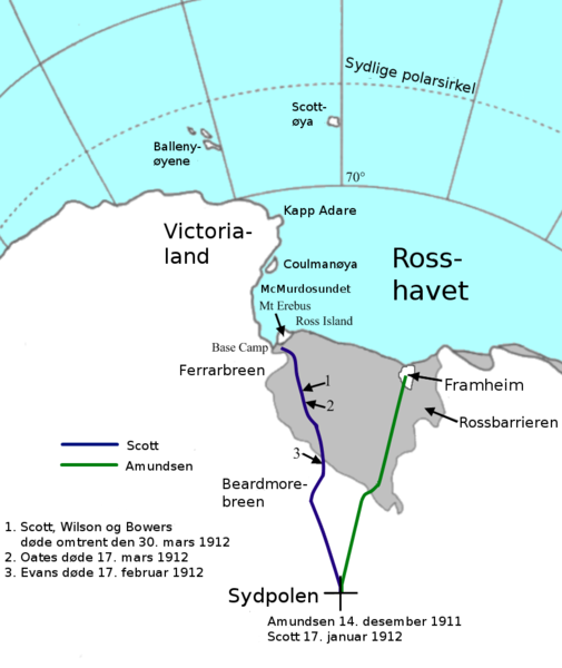
Norsk bokmål: Kart over Scott og Amundsens ekspedisjoner til Sydpolen, 1911-12. GIMP-format |
| Date | Map created 2008 |
| Source | Image:TerraNova2.png |
| Author | Yomangani, translated by Reinhardheydt and Kjetil_r |
| Other versions |
 |
| This work has been released into the public domain by its author, Yomangani. This applies worldwide. In some countries this may not be legally possible; if so: |
File history
Click on a date/time to view the file as it appeared at that time.
| Date/Time | Thumbnail | Dimensions | User | Comment | |
|---|---|---|---|---|---|
| current | 21:40, 11 November 2008 |  | 851 × 1,011 (246 KB) | Kjetil r (talk | contribs) | «Ross Ice Shelf» -> «Rossbarrieren» |
| 21:28, 11 November 2008 |  | 851 × 1,011 (249 KB) | Kjetil r (talk | contribs) | {{Information |Description={{no|Kart over Scott og Amundsens ekspedisjoner til Sydpolen, 1911-12. GIMP-format}} |Source=Image:TerraNova2.png |Date=Map created 2008 |Author=User:Yomangani, translated by User:Reinhardheydt and [[User:Kjetil_r |
You cannot overwrite this file.
File usage on Commons
There are no pages that use this file.