File:TennesseeWalkingHorseCeleb.jpg
From Wikimedia Commons, the free media repository
Jump to navigation
Jump to search
Size of this preview: 800 × 496 pixels. Other resolutions: 320 × 198 pixels | 640 × 397 pixels | 1,024 × 635 pixels | 1,280 × 794 pixels | 2,560 × 1,588 pixels | 4,800 × 2,977 pixels.
Original file (4,800 × 2,977 pixels, file size: 20.25 MB, MIME type: image/jpeg)
File information
Structured data
Captions
Summary
[edit]DescriptionTennesseeWalkingHorseCeleb.jpg |
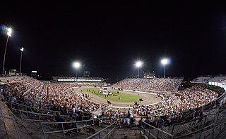
English: The Tennessee Walking Horse Celebration |
||
Date | |||
Source | Flickr [1] | ||
Author | Randall R. Saxton | ||
Permission (Reusing this file) |
This file is licensed under the Creative Commons Attribution 2.0 Generic license.
|
Camera location | 35° 29′ 27.12″ N, 86° 26′ 50.19″ W | View this and other nearby images on: OpenStreetMap | 35.490866; -86.447276 |
---|
File history
Click on a date/time to view the file as it appeared at that time.
Date/Time | Thumbnail | Dimensions | User | Comment | |
---|---|---|---|---|---|
current | 14:36, 17 November 2015 | 4,800 × 2,977 (20.25 MB) | Atsme (talk | contribs) | User created page with UploadWizard |
You cannot overwrite this file.
File usage on Commons
There are no pages that use this file.
File usage on other wikis
The following other wikis use this file:
- Usage on en.wikipedia.org
Metadata
This file contains additional information such as Exif metadata which may have been added by the digital camera, scanner, or software program used to create or digitize it. If the file has been modified from its original state, some details such as the timestamp may not fully reflect those of the original file. The timestamp is only as accurate as the clock in the camera, and it may be completely wrong.
Camera manufacturer | SONY |
---|---|
Camera model | SLT-A99V |
Exposure time | 1/125 sec (0.008) |
F-number | f/5 |
ISO speed rating | 6,400 |
Date and time of data generation | 19:42, 31 August 2013 |
Lens focal length | 16 mm |
Latitude | 35° 29′ 27.12″ N |
Longitude | 86° 26′ 50.19″ W |
Altitude | 228.96 meters above sea level |
Image title | |
Width | 6,000 px |
Height | 4,000 px |
Bits per component |
|
Pixel composition | RGB |
Orientation | Normal |
Number of components | 3 |
Horizontal resolution | 300 dpi |
Vertical resolution | 300 dpi |
Software used | Adobe Photoshop CS6 (Macintosh) |
File change date and time | 08:11, 17 November 2015 |
Offset to JPEG SOI | 139,938 |
Bytes of JPEG data | 580,203 |
Y and C positioning | Co-sited |
Exposure Program | Manual |
Exif version | 2.3 |
Date and time of digitizing | 19:42, 31 August 2013 |
Meaning of each component |
|
Image compression mode | 8 |
APEX shutter speed | 6.965784 |
APEX aperture | 4.643856 |
APEX brightness | −1.178125 |
APEX exposure bias | 0 |
Maximum land aperture | 2.96875 APEX (f/2.8) |
Metering mode | Pattern |
Light source | Unknown |
Flash | Flash did not fire, compulsory flash suppression |
Supported Flashpix version | 1 |
Color space | Uncalibrated |
File source | Digital still camera |
Scene type | A directly photographed image |
Custom image processing | Normal process |
Exposure mode | Manual exposure |
White balance | Auto white balance |
Digital zoom ratio | 1 |
Focal length in 35 mm film | 16 mm |
Scene capture type | Standard |
Contrast | Hard |
Saturation | Normal |
Sharpness | Hard |
GPS time (atomic clock) | 01:42 |
Receiver status | Measurement in progress |
Measurement mode | 3-dimensional measurement |
Measurement precision | Poor (1.8763) |
Speed unit | Kilometers per hour |
Speed of GPS receiver | 0.02 |
Reference for direction of movement | True direction |
Direction of movement | 39.85 |
Geodetic survey data used | WGS-84 |
GPS date | 1 September 2013 |
GPS differential correction | 0 |
GPS tag version | 0.0.3.2 |
Lens used | 16mm F2.8 Fisheye |
Date metadata was last modified | 02:11, 17 November 2015 |
Unique ID of original document | 80B7088AA2E8A3BE6D5D9F601A0185CA |