File:Takasaki city Joto elementary school Aerial view (2020-08).png
Jump to navigation
Jump to search
No higher resolution available.
Takasaki_city_Joto_elementary_school_Aerial_view_(2020-08).png (560 × 420 pixels, file size: 574 KB, MIME type: image/png)
Captions
Captions
Add a one-line explanation of what this file represents
Summary
[edit].png&action=edit§ion=1)
| Description |
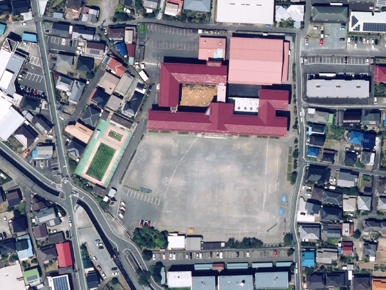
日本語: 群馬県高崎市にある高崎市立城東小学校の空中写真。校舎は真紅色の建物で、体育館と給食室は桃色の建物である。2020年8月撮影の空中写真からトリミング。 |
| Date | |
| Source | https://maps.gsi.go.jp/#18/36.326454/139.020932/&ls=nendophoto2020&disp=1&lcd=nendophoto2020&vs=c1g1j0h0k0l0u0t0z0r0s0m0f1&d=m |
| Author | 国土地理院 |
Licensing
[edit].png&action=edit§ion=2)

|
This work is licensed under the Government of Japan Standard Terms of Use (Ver.2.0). The Terms of Use are compatible with the Creative Commons Attribution License 4.0 International. For the terms of use of this work, see this license page.
|
This file is licensed under the Creative Commons Attribution 4.0 International license.
Attribution: 国土地理院 (GSI)
- You are free:
- to share – to copy, distribute and transmit the work
- to remix – to adapt the work
- Under the following conditions:
- attribution – You must give appropriate credit, provide a link to the license, and indicate if changes were made. You may do so in any reasonable manner, but not in any way that suggests the licensor endorses you or your use.
File history
Click on a date/time to view the file as it appeared at that time.
| Date/Time | Thumbnail | Dimensions | User | Comment | |
|---|---|---|---|---|---|
| current | 23:39, 4 July 2024 | | 560 × 420 (574 KB) | とらもん192 (talk | contribs) | Uploaded a work by 国土地理院 from https://maps.gsi.go.jp/#18/36.326454/139.020932/&ls=nendophoto2020&disp=1&lcd=nendophoto2020&vs=c1g1j0h0k0l0u0t0z0r0s0m0f1&d=m with UploadWizard |
You cannot overwrite this file.
File usage on Commons
There are no pages that use this file.
File usage on other wikis
The following other wikis use this file:
.png&oldid=892246547)