File:Taakeheim ill 98.png
Jump to navigation
Jump to search

Size of this preview: 521 × 599 pixels. Other resolutions: 209 × 240 pixels | 580 × 667 pixels.
Original file (580 × 667 pixels, file size: 594 KB, MIME type: image/png)
Captions
Captions
Add a one-line explanation of what this file represents
Summary
[edit]
| Description |
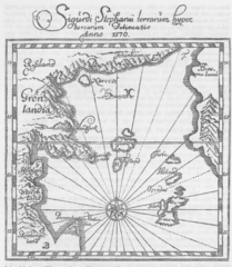
Norsk bokmål: Islandsk fremstilling av de nordlige og vestlige land som sammenhængende, av Sigurd Stefansson omkr. 1590 (Torfæus, 1706). Jfr. G. Storm, 1887, ss. 28 ff. |
| Date | |
| Source |
Fridtjof Nansen: Nord i tåkeheimen. Utforskningen av jordens nordlige strøk i tidlige tider. Jacob Dybwads Forlag. Kristiania, 1911. In the Public Domain by the National Library of Norway. |
| Author | Artist unknown. In the Public Domain by the National Library of Norway. |
Licensing
[edit]
This file is licensed under the Creative Commons Attribution-Share Alike 4.0 International license.
- You are free:
- to share – to copy, distribute and transmit the work
- to remix – to adapt the work
- Under the following conditions:
- attribution – You must give appropriate credit, provide a link to the license, and indicate if changes were made. You may do so in any reasonable manner, but not in any way that suggests the licensor endorses you or your use.
- share alike – If you remix, transform, or build upon the material, you must distribute your contributions under the same or compatible license as the original.
File history
Click on a date/time to view the file as it appeared at that time.
| Date/Time | Thumbnail | Dimensions | User | Comment | |
|---|---|---|---|---|---|
| current | 17:17, 22 February 2023 | | 580 × 667 (594 KB) | Krage52 (talk | contribs) | Uploaded a work by Artist unknown. In the Public Domain by the National Library of Norway. from Fridtjof Nansen: Nord i tåkeheimen. Utforskningen av jordens nordlige strøk i tidlige tider. Jacob Dybwads Forlag. Kristiania, 1911. In the Public Domain by the National Library of Norway. with UploadWizard |
You cannot overwrite this file.
File usage on Commons
There are no pages that use this file.
Metadata
Categories:
- North in the Misty World (1911)
- 1590 maps
- 1570 maps
- Sigurd Stefansson
- Viking Age Iceland
- Maps of Vinland
- Norse colonization of the Americas
- Old maps of the Arctic Ocean
- Old maps of the Atlantic Ocean
- Old maps of Canada
- Old maps of Frisland
- Old maps of Greenland
- 16th-century maps of Iceland
- Maps made in the 16th century
- Latin-language maps
- Skálholt
- Saga locations (Iceland)