File:Swedish-language-in-finland-map.png
Jump to navigation
Jump to search
No higher resolution available.
Swedish-language-in-finland-map.png (230 × 400 pixels, file size: 2 KB, MIME type: image/png)
Captions
Captions
Add a one-line explanation of what this file represents

|
This linguistic map image could be re-created using vector graphics as an SVG file. This has several advantages; see Commons:Media for cleanup for more information. If an SVG form of this image is available, please upload it and afterwards replace this template with
{{vector version available|new image name}}.
It is recommended to name the SVG file “Swedish-language-in-finland-map.svg”—then the template Vector version available (or Vva) does not need the new image name parameter. |
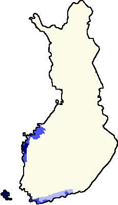
- Blue: Areas of swedish speakers in Finland
- Lightest blue: bi-lingual municipalities with Finnish majority
- Middle blue: bi-lingual municipalities with Swedish majority
- Darkest blue: unilingually Swedish municipalities
- Beige: unilingually Finnish municipalities
The map shows a sketch of the swedish-speaking and swedish-finnish bilingual areas in Finland. Municipalities outside the blue marked area have less than 8% and less than 1000 individuals speaking Swedish. Blue areas are formally bi-lingual or swedish speaking. In Tampere (the gray dot) there are 0.5% of total population and about 1000 individuals speaking swedish in the year of 1999.
Changes
[edit]
- Made by user:fragwürdig 3/7/2005, based on fi:Kuva:Suomen-läänit-template.png by fi:Käyttäjä:Jniemenmaa
- Updated by User:Tuohirulla Source: Maanmittauslaitos. Choose link from: Suomen kunnat tilaston pohjakartoilla 1.1.2005 Some changes were made to the last version. The most important changes:
- Kotka, Finnish municipality with only 1.1% swedish population (less than 600 swedish individuals in 1999, as much as there are foreigners in Kotka, also 1.1%) was changed to Finnish area
- Dragsfjärd islands changed to islands
- Added Hanko, the southernmost tip of Finland
- Traditionally finnish speaking north Bothnic areas which are also unilingually finnish municipalities were changed to Finnish areas. These municipalities are:
- Lohtaja with 0.7 per cent of population or 22 individuals being Swedish in the year of 1999
- Kälviä with 1.4%/63 individuals
- Kannus with 0.4%/25 individuals
- Himanka with 0.6%/19 individuals
- Kalajoki 0.3%/24 individuals
- and Pyhäjoki with 0.2% or 7 individuals speaking Swedish [1]
- Added Tampere with about 1000 swedish speakers, 0.5% of its total population, as a gray dot
- Coloured swedish-majority municipalities with blue. Source[2] These include municipalities of Åland islands and and from continental Finland the following:
- Liljendal and Pernaja from eastern Uusimaa
- Tammisaari, Inkoo and Karjaa from Uusimaa
- From Varsinaissuomi all the bilingual municipalities exept Turku (Särkisalo is too small to be shown with this pixel size)
- Coloured bilingually swedish municipalities with darkest blue
- From bothnia all the bilingual municipalities exept Vaasa and Kaskinen

|
Permission is granted to copy, distribute and/or modify this document under the terms of the GNU Free Documentation License, Version 1.2 or any later version published by the Free Software Foundation; with no Invariant Sections, no Front-Cover Texts, and no Back-Cover Texts. A copy of the license is included in the section entitled GNU Free Documentation License. |
| This file is licensed under the Creative Commons Attribution-Share Alike 3.0 Unported license. | ||
| ||
| This licensing tag was added to this file as part of the GFDL licensing update. |
File history
Click on a date/time to view the file as it appeared at that time.
| Date/Time | Thumbnail | Dimensions | User | Comment | |
|---|---|---|---|---|---|
| current | 19:24, 23 November 2007 | | 230 × 400 (2 KB) | Pudeo~commonswiki (talk | contribs) | Sorry, Tampere is Finnish. Now compressed version 1.82 KB |
| 19:19, 28 October 2007 |  | 230 × 400 (2 KB) | Samulili (talk | contribs) | {{do not overwrite}} | |
| 13:59, 21 October 2007 |  | 230 × 400 (6 KB) | Pudeo~commonswiki (talk | contribs) | Tampere pois, ei kaksikielinen. Kumma poikkeus muuten kartassa, ja kuvateksteihin tulee liikaa selitettävää kun pitää poikkeuksetkin selittää. | |
| 01:34, 19 February 2007 |  | 230 × 400 (2 KB) | Tene~commonswiki (talk | contribs) | Optimised (0) | |
| 12:38, 19 February 2006 |  | 230 × 400 (5 KB) | Tuohirulla (talk | contribs) | ||
| 23:32, 25 January 2006 |  | 230 × 400 (5 KB) | Tuohirulla (talk | contribs) | different shades of blue added to tell about different types of bilingualism | |
| 21:48, 25 January 2006 |  | 230 × 400 (4 KB) | Tuohirulla (talk | contribs) | better colours | |
| 21:38, 25 January 2006 |  | 230 × 400 (4 KB) | Tuohirulla (talk | contribs) | ||
| 21:04, 25 January 2006 |  | 230 × 400 (4 KB) | Tuohirulla (talk | contribs) | Added Hanko | |
| 20:15, 25 January 2006 |  | 230 × 400 (4 KB) | Tuohirulla (talk | contribs) | Inside blue areas are communities with more than 8 % or more than 3000 individuals of Swedish population. These areas are formally bilingual. Swedish speakers also exists sparsely at other areas. Source: [http://www.maanmittauslaitos.fi/Default.asp?id=122 |
You cannot overwrite this file.
File usage on Commons
The following 2 pages use this file:
File usage on other wikis
The following other wikis use this file:
- Usage on da.wikipedia.org