File:Susa valley from Sacra di San Michele.jpg
Original file (5,312 × 3,541 pixels, file size: 13.26 MB, MIME type: image/jpeg)
Captions
Summary
[edit]DescriptionSusa valley from Sacra di San Michele.jpg |
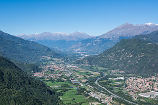
Deutsch: Der Berg Rocciamelone (3538 m) beherrscht des Susatal (Provinz Turin) durch das die Autostrada del Frejus (A32) zum Tunnel von Frejus führt. Das Tal wird vom Fluß Dora Riparia durchflossen. Am Abhang des Mont Giusalet (3312 m) ist die Druckrohrleitung des Kraftwerkes von Venaus erkennbar. English: The mountain Rocciamelone (3538 m) dominates the Susa Valley (province of Turin) through which the Autostrada del Frejus leads to the tunnel of Frejus. The river Dora Riparia flows thtrough this valley. On the slope of Mont Giusalet (3312 m) the penstock of the hydroelectric powerplant of Venaus is visible. |
Date | |
Source | Own work |
Author | Isiwal |
Camera location | 45° 05′ 53.23″ N, 7° 20′ 34.37″ E | View this and other nearby images on: OpenStreetMap | 45.098120; 7.342880 |
---|
Licensing
[edit]- You are free:
- to share – to copy, distribute and transmit the work
- to remix – to adapt the work
- Under the following conditions:
- attribution – You must give appropriate credit, provide a link to the license, and indicate if changes were made. You may do so in any reasonable manner, but not in any way that suggests the licensor endorses you or your use.
- share alike – If you remix, transform, or build upon the material, you must distribute your contributions under the same or compatible license as the original.
Annotations InfoField | This image is annotated: View the annotations at Commons |
Mont Giusalet (3312 m), distance approx. 34 km
Dents d'Ambin (3372 m), distance approx. 36 km
Mont d'Ambin (3378 m), distance approx. 37 km
Pointe Nible (3345 m), distance approx. 35 km
Pointe Ferrand (3365 m), distance approx. 35 km
Punta Sommeiller (3332 m), distance approx. 39 km
Cima del Vallonetto (3230 m), distance approx. 39 km
Penstock of hydroelectric power plant Venaus
Cime du Bard (3168 m), distance approx. 34 km
Rocciamelone (3538 m), distance approx. 24 km
Monte Palon (2970 m), distance approx. 20 km
Pointe du Ribon (3527 m), distance approx. 25 km
Pointe des Cavales (3394 m), distance approx. 25 km
Condove
Sant'Antonino di Susa
This image has been assessed using the Quality image guidelines and is considered a Quality image.
العربية ∙ جازايرية ∙ беларуская ∙ беларуская (тарашкевіца) ∙ български ∙ বাংলা ∙ català ∙ čeština ∙ Cymraeg ∙ Deutsch ∙ Schweizer Hochdeutsch ∙ Zazaki ∙ Ελληνικά ∙ English ∙ Esperanto ∙ español ∙ eesti ∙ euskara ∙ فارسی ∙ suomi ∙ français ∙ galego ∙ עברית ∙ हिन्दी ∙ hrvatski ∙ magyar ∙ հայերեն ∙ Bahasa Indonesia ∙ italiano ∙ 日本語 ∙ Jawa ∙ ქართული ∙ 한국어 ∙ kurdî ∙ Lëtzebuergesch ∙ lietuvių ∙ македонски ∙ മലയാളം ∙ मराठी ∙ Bahasa Melayu ∙ Nederlands ∙ Norfuk / Pitkern ∙ polski ∙ português ∙ português do Brasil ∙ rumantsch ∙ română ∙ русский ∙ sicilianu ∙ slovenčina ∙ slovenščina ∙ shqip ∙ српски / srpski ∙ svenska ∙ தமிழ் ∙ తెలుగు ∙ ไทย ∙ Tagalog ∙ toki pona ∙ Türkçe ∙ українська ∙ vèneto ∙ Tiếng Việt ∙ 中文 ∙ 中文(简体) ∙ 中文(繁體) ∙ +/− |
File history
Click on a date/time to view the file as it appeared at that time.
Date/Time | Thumbnail | Dimensions | User | Comment | |
---|---|---|---|---|---|
current | 15:49, 4 October 2015 | 5,312 × 3,541 (13.26 MB) | Isiwal (talk | contribs) | VicuñaUploader 1.20 |
You cannot overwrite this file.
File usage on Commons
The following 3 pages use this file:
File usage on other wikis
The following other wikis use this file:
- Usage on bg.wikipedia.org
- Usage on de.wikipedia.org
- Usage on fr.wikipedia.org
- Usage on fur.wikipedia.org
- Usage on it.wikipedia.org
- Usage on ja.wikipedia.org
- Usage on nl.wikipedia.org
- Usage on ru.wikipedia.org
Metadata
This file contains additional information such as Exif metadata which may have been added by the digital camera, scanner, or software program used to create or digitize it. If the file has been modified from its original state, some details such as the timestamp may not fully reflect those of the original file. The timestamp is only as accurate as the clock in the camera, and it may be completely wrong.
Camera manufacturer | NIKON CORPORATION |
---|---|
Camera model | NIKON D7100 |
Exposure time | 1/250 sec (0.004) |
F-number | f/8 |
ISO speed rating | 100 |
Date and time of data generation | 10:25, 24 September 2015 |
Lens focal length | 27 mm |
Latitude | 45° 5′ 53.23″ N |
Longitude | 7° 20′ 34.37″ E |
City shown | Sant'Ambrogio di Torino |
Horizontal resolution | 300 dpi |
Vertical resolution | 300 dpi |
Software used | Adobe Photoshop Lightroom 5.7 (Windows) |
File change date and time | 23:26, 3 October 2015 |
Exposure Program | Not defined |
Exif version | 2.3 |
Date and time of digitizing | 10:25, 24 September 2015 |
APEX shutter speed | 7.965784 |
APEX aperture | 6 |
APEX exposure bias | 0 |
Maximum land aperture | 4 APEX (f/4) |
Metering mode | Pattern |
Light source | Unknown |
Flash | Flash did not fire, compulsory flash suppression |
DateTimeOriginal subseconds | 50 |
DateTimeDigitized subseconds | 50 |
Focal plane X resolution | 2,558.641204834 |
Focal plane Y resolution | 2,558.641204834 |
Focal plane resolution unit | 3 |
Sensing method | One-chip color area sensor |
File source | Digital still camera |
Scene type | A directly photographed image |
Custom image processing | Normal process |
Exposure mode | Auto exposure |
White balance | Auto white balance |
Digital zoom ratio | 1 |
Focal length in 35 mm film | 40 mm |
Scene capture type | Standard |
Scene control | None |
Contrast | Normal |
Saturation | Normal |
Sharpness | Normal |
Subject distance range | Unknown |
GPS tag version | 0.0.2.2 |
Serial number of camera | 4369452 |
Lens used | 16.0-35.0 mm f/4.0 |
Date metadata was last modified | 01:26, 4 October 2015 |
Unique ID of original document | 16E47AB867850FFADF5CD082E0C4F10E |
Province or state shown | Piemonte |
Country shown | Italien |
IIM version | 4 |