File:Survey of Palestine, Jaffa - Tel Aviv (FL17237341 2369391).jpg
Jump to navigation
Jump to search
Size of this preview: 402 × 600 pixels. Other resolutions: 161 × 240 pixels | 321 × 480 pixels | 514 × 768 pixels | 686 × 1,024 pixels | 1,372 × 2,048 pixels | 3,640 × 5,432 pixels.
Original file (3,640 × 5,432 pixels, file size: 30.41 MB, MIME type: image/jpeg)
Captions
Captions
Add a one-line explanation of what this file represents
Summary
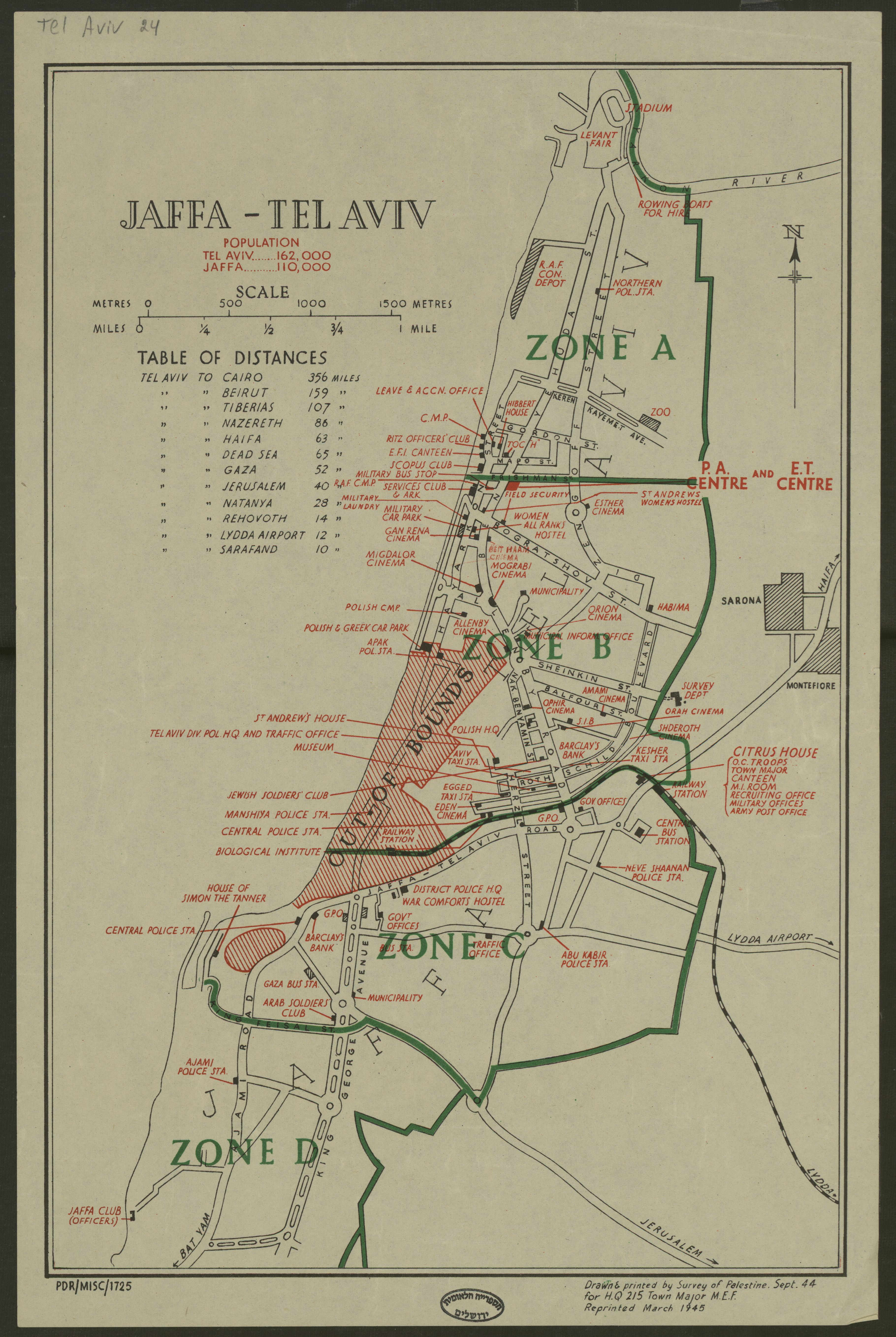
[edit]| Survey of Palestine: Jaffa - Tel Aviv
( |
||||||||||||||||||||||||
|---|---|---|---|---|---|---|---|---|---|---|---|---|---|---|---|---|---|---|---|---|---|---|---|---|
| Artist |
|
|||||||||||||||||||||||
| Title |
Jaffa - Tel Aviv |
|||||||||||||||||||||||
| Publisher |
Survey of Palestine |
|||||||||||||||||||||||
| Description |
Jaffa - Tel Aviv. Drawn & printed by Survey of Palestine Sept. 44 for H.Q. 215... Reprinted March 1945. |
|||||||||||||||||||||||
| Language | English | |||||||||||||||||||||||
| Publication date | 1945 | |||||||||||||||||||||||
| Collection |
|
|||||||||||||||||||||||
| Current location |
|
|||||||||||||||||||||||
| Place of publication | unknown | |||||||||||||||||||||||
| search Merhav catalog | unknown | |||||||||||||||||||||||
| Notes | Includes table of distances; PDR/MISC/1725.; מפת התמצאות לחייל הבריטי. | |||||||||||||||||||||||
| IE PID | IE17237339 | |||||||||||||||||||||||
| Rosetta filename | FL17237341 | |||||||||||||||||||||||
| NNL item ID (P3959) | 990023693910205171 | |||||||||||||||||||||||
| search Merhav catalog | English, Survey of Palestine | |||||||||||||||||||||||
| search Merhav catalog | Survey of Palestine | |||||||||||||||||||||||
| Source/Photographer |
|
|||||||||||||||||||||||
| Other versions | ||||||||||||||||||||||||
| Jpg / Tif version |
|
|||||||||||||||||||||||

.jpg)

.jpg&action=edit§ion=1)
Licensing
[edit].jpg&action=edit§ion=2)
This work created by the United Kingdom Government is in the public domain.
This is because it is one of the following:
HMSO has declared that the expiry of Crown Copyrights applies worldwide (ref: HMSO Email Reply)
|
 |
File history
Click on a date/time to view the file as it appeared at that time.
| Date/Time | Thumbnail | Dimensions | User | Comment | |
|---|---|---|---|---|---|
| current | 19:35, 1 August 2023 | | 3,640 × 5,432 (30.41 MB) | Geagea (talk | contribs) | pattypan 22.03 |
You cannot overwrite this file.
File usage on Commons
The following 2 pages use this file:
.jpg&oldid=802762466)