File:Styria 1418.png
Jump to navigation
Jump to search

Size of this preview: 800 × 600 pixels. Other resolutions: 320 × 240 pixels | 640 × 480 pixels | 1,024 × 768 pixels | 1,280 × 960 pixels | 2,560 × 1,920 pixels | 3,531 × 2,648 pixels.
Original file (3,531 × 2,648 pixels, file size: 1.85 MB, MIME type: image/png)
Captions
Captions
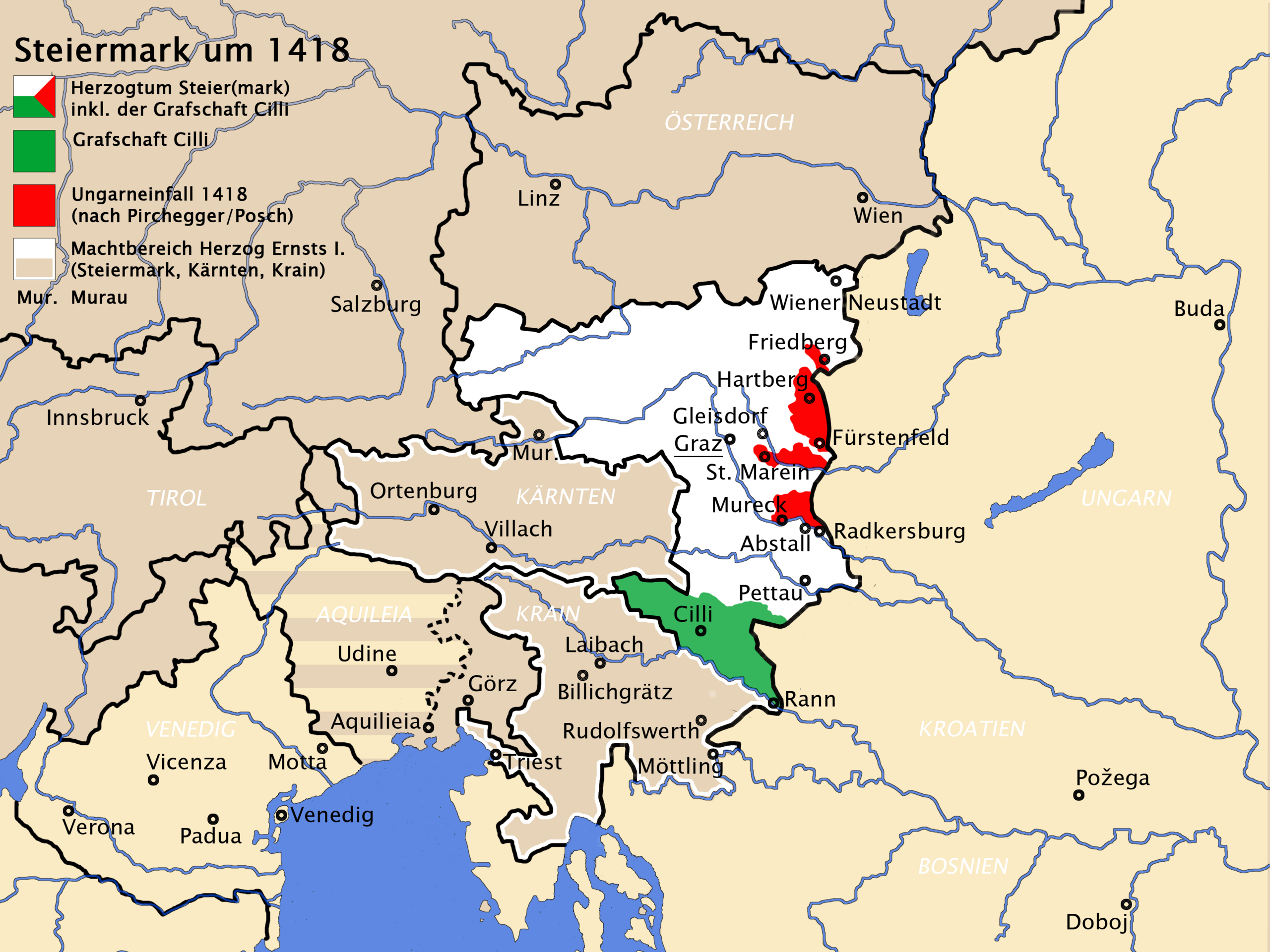
Map of the Duchy of Styria during the reign of duke Ernest the Iron
Summary
[edit]
| Description |
Deutsch: Herzogtum Steiermark um 1418
English: Duchy of Styria around 1418
|
| Date | |
| Source |
|
| Author | Roxanna |
Licensing
[edit]
I, the copyright holder of this work, hereby publish it under the following license:
This file is licensed under the Creative Commons Attribution-Share Alike 4.0 International license.
- You are free:
- to share – to copy, distribute and transmit the work
- to remix – to adapt the work
- Under the following conditions:
- attribution – You must give appropriate credit, provide a link to the license, and indicate if changes were made. You may do so in any reasonable manner, but not in any way that suggests the licensor endorses you or your use.
- share alike – If you remix, transform, or build upon the material, you must distribute your contributions under the same or compatible license as the original.
File history
Click on a date/time to view the file as it appeared at that time.
| Date/Time | Thumbnail | Dimensions | User | Comment | |
|---|---|---|---|---|---|
| current | 18:56, 11 June 2022 | | 3,531 × 2,648 (1.85 MB) | Roxanna (talk | contribs) | Wasser nicht so intensiv blau |
| 12:03, 20 May 2022 |  | 3,531 × 2,648 (1.85 MB) | Roxanna (talk | contribs) | +Triest, Padua | |
| 20:00, 11 May 2022 |  | 3,531 × 2,648 (1.85 MB) | Roxanna (talk | contribs) | +Ortenburg | |
| 09:20, 11 May 2022 |  | 3,531 × 2,648 (1.85 MB) | Roxanna (talk | contribs) | +Rann | |
| 09:04, 2 May 2022 |  | 3,531 × 2,648 (1.84 MB) | Roxanna (talk | contribs) | +Murau | |
| 18:29, 1 May 2022 |  | 3,531 × 2,648 (1.84 MB) | Roxanna (talk | contribs) | Grenze Aquileias zu Görz gestrichelt | |
| 18:02, 29 April 2022 |  | 3,531 × 2,648 (1.84 MB) | Roxanna (talk | contribs) | Aquileia gestreift, Wiener Neustadt ergänzt | |
| 16:18, 29 April 2022 |  | 3,531 × 2,648 (1.83 MB) | Roxanna (talk | contribs) | Kleinigkeiten | |
| 08:18, 29 April 2022 |  | 3,531 × 2,648 (1.83 MB) | Roxanna (talk | contribs) | {{Information |Description= {{de|1=Herzogtum Steiermark um 1418 *weiß, rot und grün: Herzogtum Steiermark zu Beginn des 15. Jahrhunderts (nach Westermann/Shepherd) *grün: Grafschaft Cilli innerhalb des Herzogtums Steiermark inkl. der Grafschaft Cilli (nach Westermann) *rot: Beim Ungarneinfall 1418 verheertes Gebiet (nach Pirchegger/Posch) *weiß und weiß umrandet: Machbereich des Herzogs Ernst I. (Steiermark, Kärnten und Krain) }} {{en|1=Duchy of Styria around 1418 *white, red and green: Duchy... |
You cannot overwrite this file.
File usage on Commons
The following page uses this file:
File usage on other wikis
The following other wikis use this file: