File:Straube Droschken-Wegemesser für die Umgebung von Berlin 1888.jpg
Jump to navigation
Jump to search

Size of this preview: 734 × 600 pixels. Other resolutions: 294 × 240 pixels | 587 × 480 pixels | 940 × 768 pixels | 1,253 × 1,024 pixels | 2,506 × 2,048 pixels | 5,636 × 4,607 pixels.
Original file (5,636 × 4,607 pixels, file size: 18.87 MB, MIME type: image/jpeg)
Captions
Captions
Add a one-line explanation of what this file represents
Summary
[edit]| Title |
Droschken-Wegemesser für die Umgebung von Berlin - Oktober 1888 |
| Description |
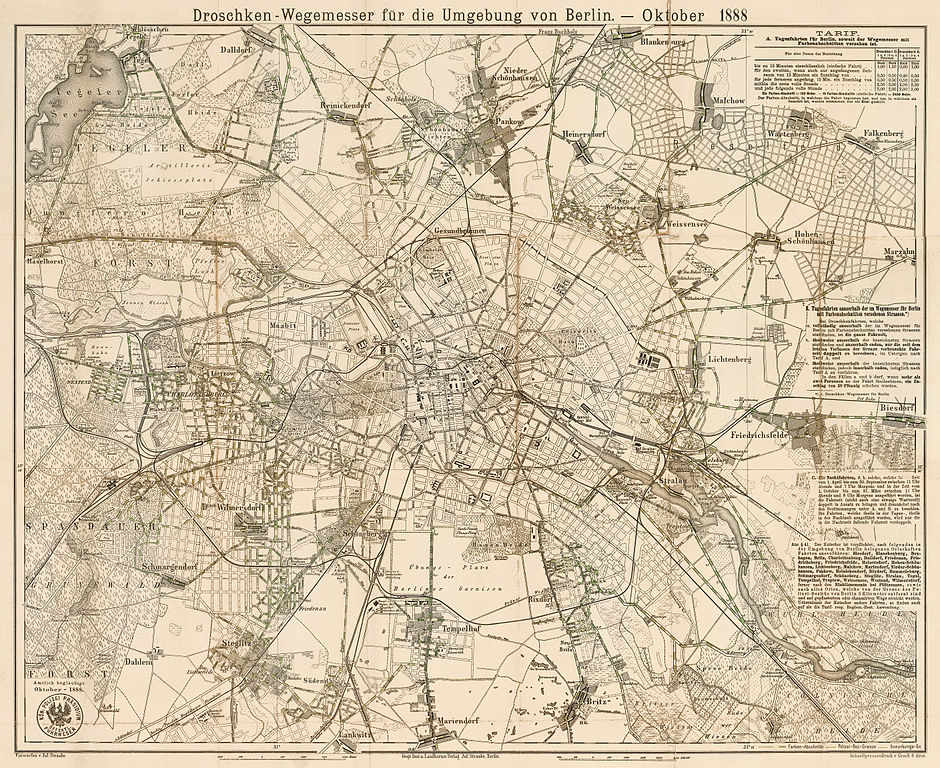
Deutsch: Kopie von 1888 des 1880 erstmals erschienenen Droschken-Wegemessers für die Umgebung von Berlin. Der Plan reicht von Haselhorst bis Biesdorf und von Dalldorf bis Lankwitz. Der Titel steht einzeilig über dem Plan. Unter dem Plan zwei Maßstabsleisten über "2000 Meter" sowie "2000 Schritt". Rechts unten (im Gegensatz zur Erstausgabe): "Schnellpressendruck v. Grack & Aron". Im Plan auf der rechten Seite sind die Tarife A, B und C erklärt. |
| Date | |
| Source | Landesarchiv Berlin (online) |
| Creator | |
| Geotemporal data | |
| Map location | Berlin |
| Scale | 1:36,000 |
| Heading |
 |
| Georeferencing | |
| Bibliographic data | |
| Language | German |
| Publisher |
Geographisches Institut und Landkartenverlag Julius Straube |
| Printed by |
Schnellpressendruck v. Grack & Aron |
| Archival data | |
| Collection | Landesarchiv Berlin |
| Accession number |
F Rep. 270, A 3144 |
| Dimensions | height: 51.1 cm (20.1 in); width: 61.6 cm (24.2 in) (height: 48.2 cm (18.9 in); width: 60 cm (23.6 in) map size) |
| Medium | chromolithograph |
| Notes |
Literatur
|
| Other versions | |
.jpg)
Licensing
[edit]
|
This is a faithful photographic reproduction of a two-dimensional, public domain work of art. The work of art itself is in the public domain for the following reason:
The official position taken by the Wikimedia Foundation is that "faithful reproductions of two-dimensional public domain works of art are public domain".
This photographic reproduction is therefore also considered to be in the public domain in the United States. In other jurisdictions, re-use of this content may be restricted; see Reuse of PD-Art photographs for details. | ||||
File history
Click on a date/time to view the file as it appeared at that time.
| Date/Time | Thumbnail | Dimensions | User | Comment | |
|---|---|---|---|---|---|
| current | 16:05, 24 November 2012 | | 5,636 × 4,607 (18.87 MB) | Alexrk2 (talk | contribs) | {{InteractiveViewer}} {{Information |Description='''Droschken-Wegemesser für die Umgebung von Berlin''' - Oktober 1888 * Format: 60,0 x 48,2 cm (nur der Plan) * Maßstab: ca 1:36.000 * Orientierung: Nord * Lithografie teilkol. ; Merkmale Kopie von 188... |
You cannot overwrite this file.
File usage on Commons
The following page uses this file: