File:Status of upstream watershed development in Texas LOC 85693941.tif
Jump to navigation
Jump to search

Size of this JPG preview of this TIF file: 800 × 559 pixels. Other resolutions: 320 × 224 pixels | 640 × 447 pixels | 1,024 × 716 pixels | 1,280 × 894 pixels | 2,560 × 1,789 pixels | 5,982 × 4,180 pixels.
Original file (5,982 × 4,180 pixels, file size: 71.54 MB, MIME type: image/tiff)
Captions
Captions
Add a one-line explanation of what this file represents
Summary
[edit]| Description |
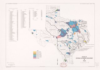
English: Shows watershed projection and flood prevention projects. "Base extracted from 1:1,000,000 SCS national atlas base map." "Source: Data compiled by Watershed Planning Staff." In left lower corner: 4-R-14742. Available also through the Library of Congress Web site as a raster image. |
||
| Title | Status of upstream watershed development in Texas | ||
| Shelf ID | G4031.N22 1984 .U5 | ||
| Date | |||
| Source | https://www.loc.gov/item/85693941/ | ||
| Author | United States. Soil Conservation Service | ||
| Permission (Reusing this file) |
|
||
| Other versions |
|
||
| Location | United States · Texas. · Texas | ||
| Part of | American Memory · General Maps · Catalog · Geography And Map Division | ||
| Subject | Watershed Management · Maps · United States · Texas · Flood Control |


Licensing
[edit]| This work is from the Library of Congress. According to the library, there are no known copyright restrictions on the use of this work. |  |
File history
Click on a date/time to view the file as it appeared at that time.
| Date/Time | Thumbnail | Dimensions | User | Comment | |
|---|---|---|---|---|---|
| current | 02:55, 23 August 2019 |  | 5,982 × 4,180 (71.54 MB) | Fæ (talk | contribs) | LOC Maps https://www.loc.gov/item/85693941/ #3715 |
You cannot overwrite this file.
File usage on Commons
The following page uses this file: