File:Speyer Topography.pdf
Jump to navigation
Jump to search

Size of this JPG preview of this PDF file: 424 × 600 pixels. Other resolutions: 170 × 240 pixels | 339 × 480 pixels | 543 × 768 pixels | 1,239 × 1,752 pixels.
Original file (1,239 × 1,752 pixels, file size: 426 KB, MIME type: application/pdf)
Captions
Captions
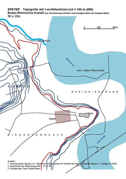
Topography of Speyer with the location of the first Roman castrum 10 BC
Summary
[edit]| Description |
English: The elevation of 100 m is shown red. The cathedral and main streets of Speyer are shown for orientation, blue is the assumed ancient course of the Rhine |
| Date | |
| Source | Own work |
| Author | Sundar1 |
Licensing
[edit]I, the copyright holder of this work, hereby publish it under the following license:
This file is licensed under the Creative Commons Attribution-Share Alike 4.0 International license.
- You are free:
- to share – to copy, distribute and transmit the work
- to remix – to adapt the work
- Under the following conditions:
- attribution – You must give appropriate credit, provide a link to the license, and indicate if changes were made. You may do so in any reasonable manner, but not in any way that suggests the licensor endorses you or your use.
- share alike – If you remix, transform, or build upon the material, you must distribute your contributions under the same or compatible license as the original.
File history
Click on a date/time to view the file as it appeared at that time.
| Date/Time | Thumbnail | Dimensions | User | Comment | |
|---|---|---|---|---|---|
| current | 12:59, 3 December 2019 |  | 1,239 × 1,752 (426 KB) | Sundar1 (talk | contribs) | User created page with UploadWizard |
You cannot overwrite this file.
File usage on Commons
There are no pages that use this file.
File usage on other wikis
The following other wikis use this file:
- Usage on de.wikipedia.org