File:Sources Loiret-plan 3.png
Jump to navigation
Jump to search
No higher resolution available.
Sources_Loiret-plan_3.png (755 × 532 pixels, file size: 657 KB, MIME type: image/png)
Captions
Captions
Add a one-line explanation of what this file represents
Summary
[edit]
| Description |
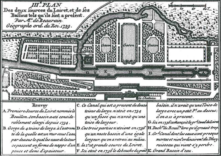
English: 3rd map of the grounds of the "château de la Source" in Orléans, detailing the springs of the Loiret river, made in 1739 by Mr de Beaurain, king's geographer.
Français : 3e carte des sources du Loiret, faite en 1739 par Mr de Beaurain,géographe ordinaire du roi. |
| Date | |
| Source | Book : abbé de Fontenu, "Réflexions historiques sur le Loiret." In "Mémoires de l'Académie Royale des Inscriptions et Belles Lettres", Tome XII, 153-163. |
| Author | Beaurain (only indication for the author of the maps, in above-mentioned book) |
| Camera location | | View this and other nearby images on: OpenStreetMap |
|---|
Licensing
[edit]
|
This work is in the public domain in its country of origin and other countries and areas where the copyright term is the author's life plus 70 years or fewer. This work is in the public domain in the United States because it was published (or registered with the U.S. Copyright Office) before January 1, 1929. | |
| This file has been identified as being free of known restrictions under copyright law, including all related and neighboring rights. | |
File history
Click on a date/time to view the file as it appeared at that time.
| Date/Time | Thumbnail | Dimensions | User | Comment | |
|---|---|---|---|---|---|
| current | 18:18, 20 September 2017 | | 755 × 532 (657 KB) | Basicdesign (talk | contribs) | User created page with UploadWizard |
You cannot overwrite this file.
File usage on Commons
There are no pages that use this file.
File usage on other wikis
The following other wikis use this file:
- Usage on fi.wikipedia.org
- Usage on fr.wikipedia.org