File:SomosValenzuelaHESS2016-fig1-mode-en.png
Jump to navigation
Jump to search

Size of this preview: 681 × 600 pixels. Other resolutions: 273 × 240 pixels | 545 × 480 pixels | 872 × 768 pixels | 1,163 × 1,024 pixels | 2,326 × 2,048 pixels | 4,724 × 4,159 pixels.
Original file (4,724 × 4,159 pixels, file size: 3.01 MB, MIME type: image/png)
Captions
Captions
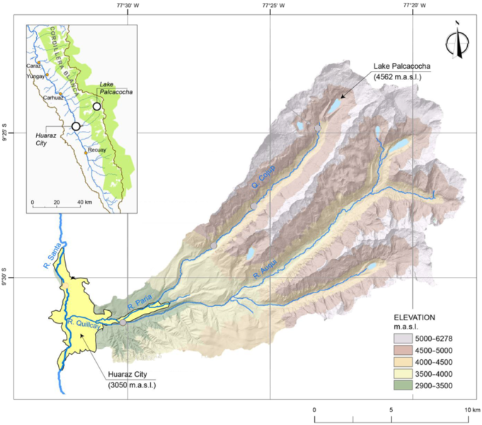
Map of the Quillcay watershed, including the city of Huaraz and Lake Palcacocha. Based on a digital elevation model.
Summary
[edit]
| Description |
English: Map of the Quillcay watershed, including the city of en:Huaraz and Lake en:Palcacocha. Based on a digital elevation model.
Deutsch: Karte des Wassereinzugsgebiets des Rio Quillcay, mit der Stadt de:Huaraz und Laguna de:Palcacocha, basierend auf einem digitalen Höhenmodell. |
| Date | |
| Source | Somos-Valenzuela et al. "Modeling a glacial lake outburst flood process chain: the case of Lake Palcacocha and Huaraz, Peru". In: Hydrol. Earth Syst. Sci., 20, 2519–2543, 2016, figure 1. DOI: 10.5194/hess-20-2519-2016 . Based on digital elevation model (DEM) of the Quillcay watershed. Modifications: indications of cross sections blended with surrounding colors) |
| Author | Original image: Somos-Valenzuela et al., modification: User:DeWikiMan |
The material has been made available by the journal under a creative commons attribution license, for the license policy see https://www.hydrology-and-earth-system-sciences.net/about/licence_and_copyright.html
Licensing
[edit]
This file is licensed under the Creative Commons Attribution-Share Alike 3.0 Unported license.
Attribution: Original image: Somos-Valenzuela et al. "Modeling a glacial lake outburst flood process chain: the case of Lake Palcacocha and Huaraz, Peru". In: Hydrol. Earth Syst. Sci., 20, 2519–2543, 2016, figure 1. DOI: 10.5194/hess-20-2519-2016 . Modifications of original: indications of cross sections blended with surrounding colors
- You are free:
- to share – to copy, distribute and transmit the work
- to remix – to adapt the work
- Under the following conditions:
- attribution – You must give appropriate credit, provide a link to the license, and indicate if changes were made. You may do so in any reasonable manner, but not in any way that suggests the licensor endorses you or your use.
- share alike – If you remix, transform, or build upon the material, you must distribute your contributions under the same or compatible license as the original.
File history
Click on a date/time to view the file as it appeared at that time.
| Date/Time | Thumbnail | Dimensions | User | Comment | |
|---|---|---|---|---|---|
| current | 09:57, 20 May 2018 | | 4,724 × 4,159 (3.01 MB) | DeWikiMan (talk | contribs) | {{Information |description ={{en|1=Map of the Quillcay watershed, including the city of en:Huaraz and Lake en:Palcacocha. Based on a digital elevation model.}} {{de|1=Karte des Wassereinzugsgebiets des Rio Quillcay, mit der Stadt de:Huaraz und Laguna de:Palcacocha, basierend auf einem digitalen Höhenmodell.}} |source =Somos-Valenzuela et al. "Modeling a glacial lake outburst flood process chain: the case of Lake Palcacocha and Huaraz, Peru". In: Hydrol. Earth Syst... |
You cannot overwrite this file.
File usage on Commons
There are no pages that use this file.
File usage on other wikis
The following other wikis use this file:
- Usage on de.wikipedia.org
- Usage on es.wikipedia.org
- Usage on pt.wikipedia.org