File:Smith 1963 USGS Professional Paper 363 plate-1.jpg
Jump to navigation
Jump to search

Size of this preview: 523 × 600 pixels. Other resolutions: 209 × 240 pixels | 418 × 480 pixels | 669 × 768 pixels | 893 × 1,024 pixels | 1,785 × 2,048 pixels | 15,553 × 17,840 pixels.
Original file (15,553 × 17,840 pixels, file size: 24.63 MB, MIME type: image/jpeg)
Captions
Captions
Add a one-line explanation of what this file represents
Summary
[edit]
| Warning | The original file is very high-resolution. It might not load properly or could cause your browser to freeze when opened at full size. |
|---|
| Description |
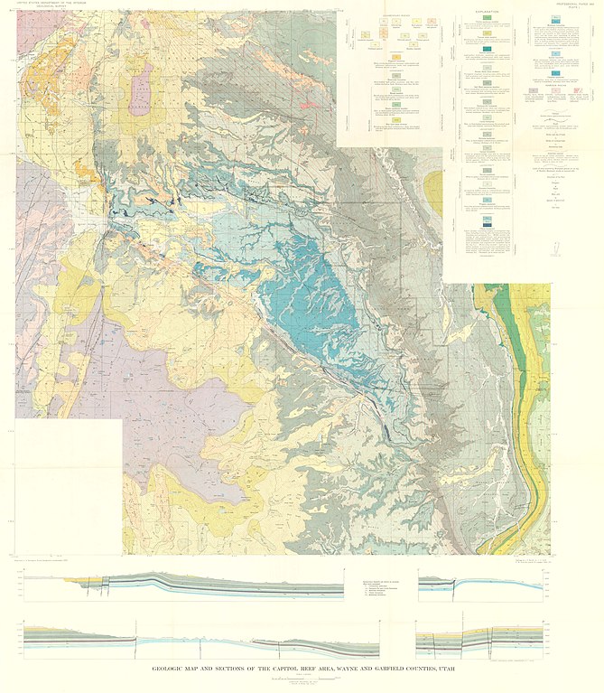
English: Geologic map and sections of the Capitol Reef area, Wayne and Garfield counties, Utah. Scale 1:62,500. Plate 1 of Geology of the Capitol Reef area, Wayne and Garfield Counties, Utah, USGS Professional Paper 363. |
| Date | |
| Source | https://pubs.er.usgs.gov/publication/pp363 |
| Author | Smith, J. Fred Jr; Huff, Lyman C.; Hinrichs, E.Neal; Luedke, Robert G. |
Licensing
[edit]
This image is in the public domain in the United States because it only contains materials that originally came from the United States Geological Survey, an agency of the United States Department of the Interior. For more information, see the official USGS copyright policy.
|
File history
Click on a date/time to view the file as it appeared at that time.
| Date/Time | Thumbnail | Dimensions | User | Comment | |
|---|---|---|---|---|---|
| current | 03:38, 19 December 2018 | | 15,553 × 17,840 (24.63 MB) | Kognos (talk | contribs) | User created page with UploadWizard |
You cannot overwrite this file.
File usage on Commons
The following page uses this file: