File:Shaking of BP Exploration Building, M7 Nov. 30, 2018, Anchorage Quake.webm
Original file (WebM audio/video file, VP9/Opus, length 2 min 43 s, 1,920 × 1,080 pixels, 1.05 Mbps overall, file size: 20.51 MB)
Captions
Captions
Summary
[edit]| Description |
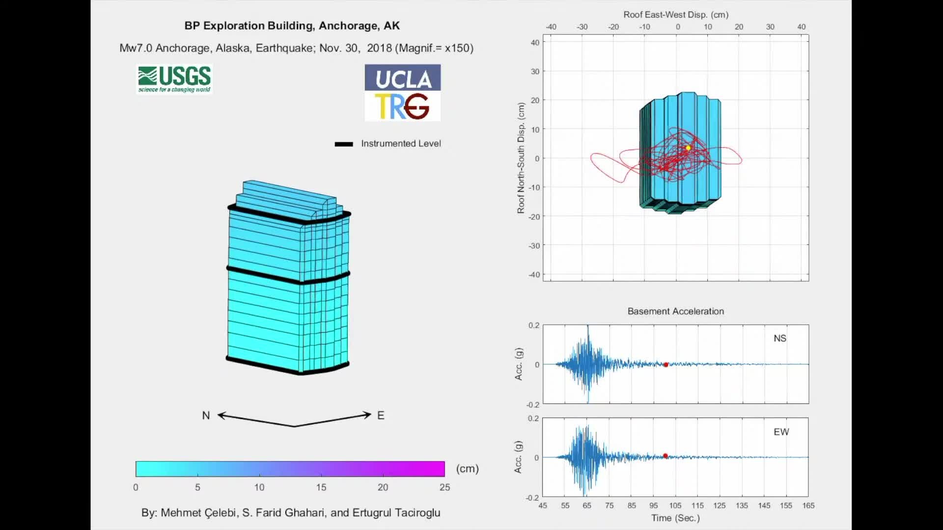
English: This video presents a visualization of how the BP Exploration Building in Anchorage, Alaska, shook during the moment magnitude (Mw) 7.0 November 30, 2018, Anchorage, Alaska, earthquake. The building was instrumented by U.S. Geological Survey (USGS) to obtain data to study its behavior and performance during strong shaking. Such data are useful in making decisions about improving the performance of this and similar buildings.
Note that relative to the height of the building, the motions are magnified by a factor of 150 to show how the building deforms. Translational (back-and-forth) motion (dominant in the east direction) and limited torsional (twisting) motions are observed. Please note that the 14-story BP Exploration Building is sparsely instrumented, having sensors at the ground, 8th, and 14th (roof) levels only (shown in the video as heavy black lines). Therefore, in developing the video, we used interpolation of displacements between the roof and 8th floor and between the 8th floor and ground level. As a result, in the visualization, only the displacements at the ground, 8th, and 14th (roof) levels should be considered accurate. The other level displacements are the result of interpolation. Find this video and thousands more at https://usgs.gov/gallery. Stay up-to-date on USGS topics and news on Twitter, Instagram, Facebook and more at https://usgs.gov/socialmedia. DYK? The USGS.gov site is completely mobile! Ditch the desktop and browse the latest earth science on your mobile device. Go to https://usgs.gov. |
| Date | |
| Source | YouTube: Shaking of BP Exploration Building, M7 Nov. 30, 2018, Anchorage Quake – View/save archived versions on archive.org and archive.today |
| Author | USGS |
Licensing
[edit]This image is in the public domain in the United States because it only contains materials that originally came from the United States Geological Survey, an agency of the United States Department of the Interior. For more information, see the official USGS copyright policy.
|

|
This file, which was originally posted to an external website, has not yet been reviewed by an administrator or reviewer to confirm that the above license is valid. See Category:License review needed for further instructions.
|
File history
Click on a date/time to view the file as it appeared at that time.
| Date/Time | Thumbnail | Dimensions | User | Comment | |
|---|---|---|---|---|---|
| current | 09:22, 30 July 2023 | 2 min 43 s, 1,920 × 1,080 (20.51 MB) | Fumikas Sagisavas (talk | contribs) | Imported media from https://www.youtube.com/watch?v=NKOdkmrjYWA |
You cannot overwrite this file.
File usage on Commons
The following page uses this file: