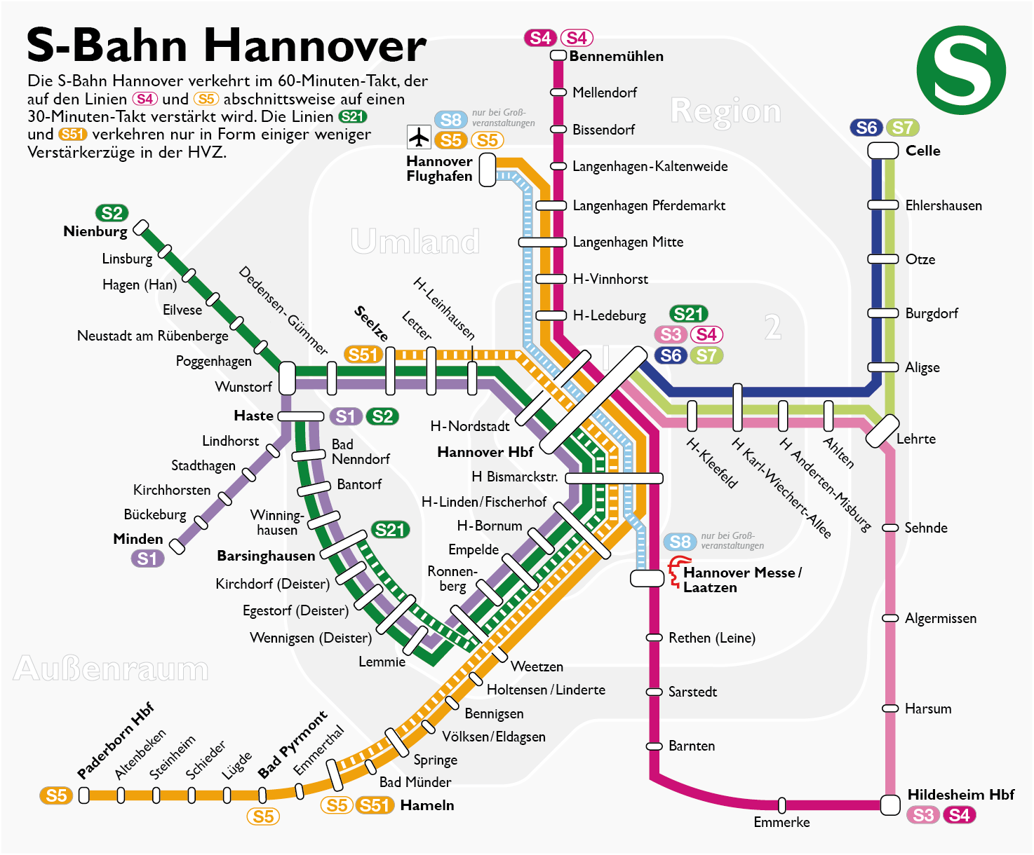
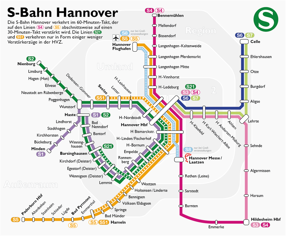
File:Schemaplan der S-Bahn Hannover.png
Jump to navigation
Jump to search
Size of this preview: 724 × 599 pixels. Other resolutions: 290 × 240 pixels | 580 × 480 pixels | 928 × 768 pixels | 1,237 × 1,024 pixels | 1,474 × 1,220 pixels.
Original file (1,474 × 1,220 pixels, file size: 321 KB, MIME type: image/png)
Captions
Captions
Add a one-line explanation of what this file represents
| Description |
|
| Date | |
| Source | Self made, inspired by this map of Hein Spock and using the followig files: (1) (2) (3). Information about the recent S-Bahn network is from here and here. |
| Author | Maximilian Dörrbecker (Chumwa) |
| Permission (Reusing this file) |
I, the copyright holder of this work, hereby publish it under the following license: This file is licensed under the Creative Commons Attribution-Share Alike 2.5 Generic license.
Sie dürfen das Bild zu den folgenden Bedingungen nutzen:
|

|
This transport map image could be re-created using vector graphics as an SVG file. This has several advantages; see Commons:Media for cleanup for more information. If an SVG form of this image is available, please upload it and afterwards replace this template with
{{vector version available|new image name}}.
It is recommended to name the SVG file “Schemaplan der S-Bahn Hannover.svg”—then the template Vector version available (or Vva) does not need the new image name parameter. |
File history
Click on a date/time to view the file as it appeared at that time.
| Date/Time | Thumbnail | Dimensions | User | Comment | |
|---|---|---|---|---|---|
| current | 19:18, 13 April 2016 | | 1,474 × 1,220 (321 KB) | Nobelium (talk | contribs) | Corrected stop names. And unfortunately larger file again... |
| 06:57, 23 August 2015 |  | 1,474 × 1,220 (184 KB) | Kopiersperre (talk | contribs) | fehler gemacht | |
| 06:56, 23 August 2015 |  | 1,103 × 1,006 (196 KB) | Kopiersperre (talk | contribs) | optipng | |
| 04:43, 22 August 2015 |  | 1,474 × 1,220 (309 KB) | Chumwa (talk | contribs) | S5 hält auch in Weetzen | |
| 07:52, 13 September 2014 |  | 1,474 × 1,220 (308 KB) | Chumwa (talk | contribs) | nicht alles hält überall... | |
| 16:11, 14 August 2014 |  | 1,474 × 1,220 (309 KB) | Chumwa (talk | contribs) | Aktualisierung: S21 und S51 | |
| 19:24, 22 August 2011 |  | 1,474 × 1,170 (255 KB) | Chumwa (talk | contribs) | und nochmal... | |
| 19:21, 22 August 2011 |  | 1,474 × 1,170 (250 KB) | Chumwa (talk | contribs) | Korrektor an den Tarifzonengrenzen (bei Sarstedt und Barnten) | |
| 20:14, 29 June 2009 |  | 1,474 × 1,170 (255 KB) | Chumwa (talk | contribs) | Paderborn → Paderborn Hbf | |
| 19:18, 28 June 2009 |  | 1,474 × 1,170 (254 KB) | Chumwa (talk | contribs) | zwei Bahnhofsnamen korrigiert |
You cannot overwrite this file.
File usage on Commons
The following 10 pages use this file:
- User:Chumwa/Gallery
- User:Chumwa/OgreBot/Potential transport maps/2016 April 11-20
- User:Chumwa/OgreBot/Public transport information/2015 August 21-31
- User:Chumwa/OgreBot/Public transport information/2016 April 11-20
- User:Chumwa/OgreBot/Transport Maps/2015 August 21-31
- User:Chumwa/OgreBot/Transport Maps/2016 April 11-20
- User:Chumwa/OgreBot/Travel and communication maps/2016 April 11-20
- User:Chumwa/Railway maps
- User:Nordlicht8/Rail Germany/2015 August 21-31
- User:Nordlicht8/Rail Germany/2016 April 11-20
File usage on other wikis
The following other wikis use this file:
- Usage on de.wikipedia.org