File:Satellite radar topography of Guatemala.jpg
Jump to navigation
Jump to search

Size of this preview: 800 × 600 pixels. Other resolutions: 320 × 240 pixels | 640 × 480 pixels | 1,024 × 768 pixels.
Original file (1,024 × 768 pixels, file size: 82 KB, MIME type: image/jpeg)
Captions
Captions
Add a one-line explanation of what this file represents
Summary
[edit]
| Description |
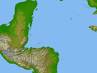
English: Satellite radar topography image of a portion of Central America. Due to persistent cloud cover, obtaining conventional high-altitude photos of this region is extraordinarily difficult. Radar's ability to penetrate clouds and make 3-D measurements allowed scientists to generate the first complete high-resolution topographic map of the entire region. All of Guatemala, Belize, El Salvador, and Honduras are visible on this image, as well as a considerable portion of southern Mexico (the Yucatan Peninsula). Image courtesy of NASA/JPL/NGA. |
| Date | |
| Source | https://www.cia.gov/library/publications/the-world-factbook/photo_gallery/images/large/GT_006_large.jpg |
| Author | NASA/JPL/NGA |
Licensing
[edit]
| This file is in the public domain in the United States because it was solely created by NASA. NASA copyright policy states that "NASA material is not protected by copyright unless noted". (See Template:PD-USGov, NASA copyright policy page or JPL Image Use Policy.) | ||
 |
Warnings:
|
File history
Click on a date/time to view the file as it appeared at that time.
| Date/Time | Thumbnail | Dimensions | User | Comment | |
|---|---|---|---|---|---|
| current | 22:54, 19 July 2011 | | 1,024 × 768 (82 KB) | Arjuno3 (talk | contribs) |
You cannot overwrite this file.
File usage on Commons
There are no pages that use this file.
File usage on other wikis
The following other wikis use this file:
- Usage on pt.wikipedia.org