File:SanRafealReef2.jpg
Jump to navigation
Jump to search

Size of this preview: 800 × 218 pixels. Other resolutions: 320 × 87 pixels | 640 × 174 pixels | 1,024 × 279 pixels | 3,009 × 819 pixels.
Original file (3,009 × 819 pixels, file size: 668 KB, MIME type: image/jpeg)
Captions
Captions
Add a one-line explanation of what this file represents
Summary
[edit]
| Description | |
| Date | |
| Source | Own work |
| Author | Davemeistermoab |
| Camera location | | View this and other nearby images on: OpenStreetMap |
|---|
Licensing
[edit]
I, Davemeistermoab, the copyright holder of this work, hereby publishes it under the following licenses:

|
Permission is granted to copy, distribute and/or modify this document under the terms of the GNU Free Documentation License, Version 1.2 or any later version published by the Free Software Foundation; with no Invariant Sections, no Front-Cover Texts, and no Back-Cover Texts. A copy of the license is included in the section entitled GNU Free Documentation License. |
| This file is licensed under the Creative Commons Attribution-Share Alike 3.0 Unported license. | ||
| Attribution: I, Davemeistermoab | ||
| ||
| This licensing tag was added to this file as part of the GFDL licensing update. |
You may select the license of your choice.
File history
Click on a date/time to view the file as it appeared at that time.
| Date/Time | Thumbnail | Dimensions | User | Comment | |
|---|---|---|---|---|---|
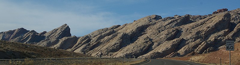
| current | 02:51, 5 June 2008 | 3,009 × 819 (668 KB) | Moabdave (talk | contribs) | {{Information |Description= {{en|Entrance to the San Rafael Swell as seen from a View area along Interstate 70}} |Source=self-made |Date=2007 |Author= Davemeistermoab }} == Licensing == { | |
| 05:56, 15 May 2008 |  | 3,008 × 2,000 (2.21 MB) | Moabdave (talk | contribs) | {{Information |Description= {{en|Entrance to the San Rafael Swell as seen from a View area along Interstate 70 in Utah}} |Source=self-made |Date=2003 |Author= Davemeistermoab }} = | |
| 04:47, 18 July 2007 |  | 640 × 480 (222 KB) | Moabdave (talk | contribs) | {{Information |Description= Entrance to the w:San Rafael Swell as seen from a View area along w:Interstate 70 |Source=self-made |Date=2003 |Author= Davemeistermoab }} category:Interstate 70category:San Rafael Swell |
You cannot overwrite this file.
File usage on Commons
The following page uses this file:
File usage on other wikis
The following other wikis use this file:
- Usage on en.wikipedia.org
Metadata
Categories:
- Locations along Utah State Route 4 (1962-1977) in Emery County, Utah
- Locations along Interstate 70 in Emery County, Utah
- San Rafael Reef
- Colorado Plateau region of Utah
- Locations along U.S. Route 50 in Emery County, Utah
- Speed limit road signs in Utah
- 60 mph speed limit road signs in the United States
- December 2007 in Utah