File:Sam 2021-09-26 1150Z-2000Z.gif
Jump to navigation
Jump to search

Size of this preview: 592 × 600 pixels. Other resolutions: 237 × 240 pixels | 474 × 480 pixels | 758 × 768 pixels | 1,010 × 1,024 pixels | 1,939 × 1,965 pixels.
Original file (1,939 × 1,965 pixels, file size: 49.59 MB, MIME type: image/gif, looped, 17 frames, 2.7 s)
Captions
Captions
Add a one-line explanation of what this file represents
Summary
[edit]
| Description |
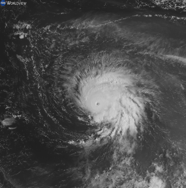
English: This is a Satellite loop of Hurricane Sam the eighteenth named storm, seventh hurricane, and fourth major hurricane of the active 2021 Atlantic hurricane season, this loop of Sam was recorded between 11:50 to 20:00 (UTC) (7:50 AM to 4:00 PM) (Local Time) on Sunday September 26th, 2021, during this period Sam was strengthening up until the very last frame of the loop which was around its peak intensity, this loop was taken from red visible band aboard NOAA's GOES-16 satellite. The official peak of Hurricane Sam was maximum sustained winds of 155 MPH (250 KMH or 135 KNOTS) and a minimum central pressure of 929 Millibars (hPa) making it just as intense as Hurricane Ida that occurred a month prior though Hurricane Sam is stronger in terms of maximum sustained winds. |
| Date | |
| Source | https://worldview.earthdata.nasa.gov/ |
| Author | NASA (Website) NOAA (Satellite) |
Licensing
[edit]
| This file is in the public domain in the United States because it was solely created by NASA. NASA copyright policy states that "NASA material is not protected by copyright unless noted". (See Template:PD-USGov, NASA copyright policy page or JPL Image Use Policy.) | ||
 |
Warnings:
|
This image is in the public domain because it contains materials that originally came from the U.S. National Oceanic and Atmospheric Administration, taken or made as part of an employee's official duties.
|
File history
Click on a date/time to view the file as it appeared at that time.
| Date/Time | Thumbnail | Dimensions | User | Comment | |
|---|---|---|---|---|---|
| current | 19:04, 27 September 2021 | | 1,939 × 1,965 (49.59 MB) | TheWxResearcher (talk | contribs) | Uploaded a work by NASA (Website) NOAA (Satellite) from https://worldview.earthdata.nasa.gov/ with UploadWizard |
You cannot overwrite this file.
File usage on Commons
There are no pages that use this file.