File:Salt trade in Wallachia (16th–19th centuries).svg
Jump to navigation
Jump to search

Size of this PNG preview of this SVG file: 792 × 599 pixels. Other resolutions: 317 × 240 pixels | 634 × 480 pixels | 1,015 × 768 pixels | 1,280 × 969 pixels | 2,560 × 1,937 pixels | 1,003 × 759 pixels.
Original file (SVG file, nominally 1,003 × 759 pixels, file size: 1.87 MB)
Captions
Captions
Add a one-line explanation of what this file represents
Summary
[edit].svg&action=edit§ion=1)
| Description |
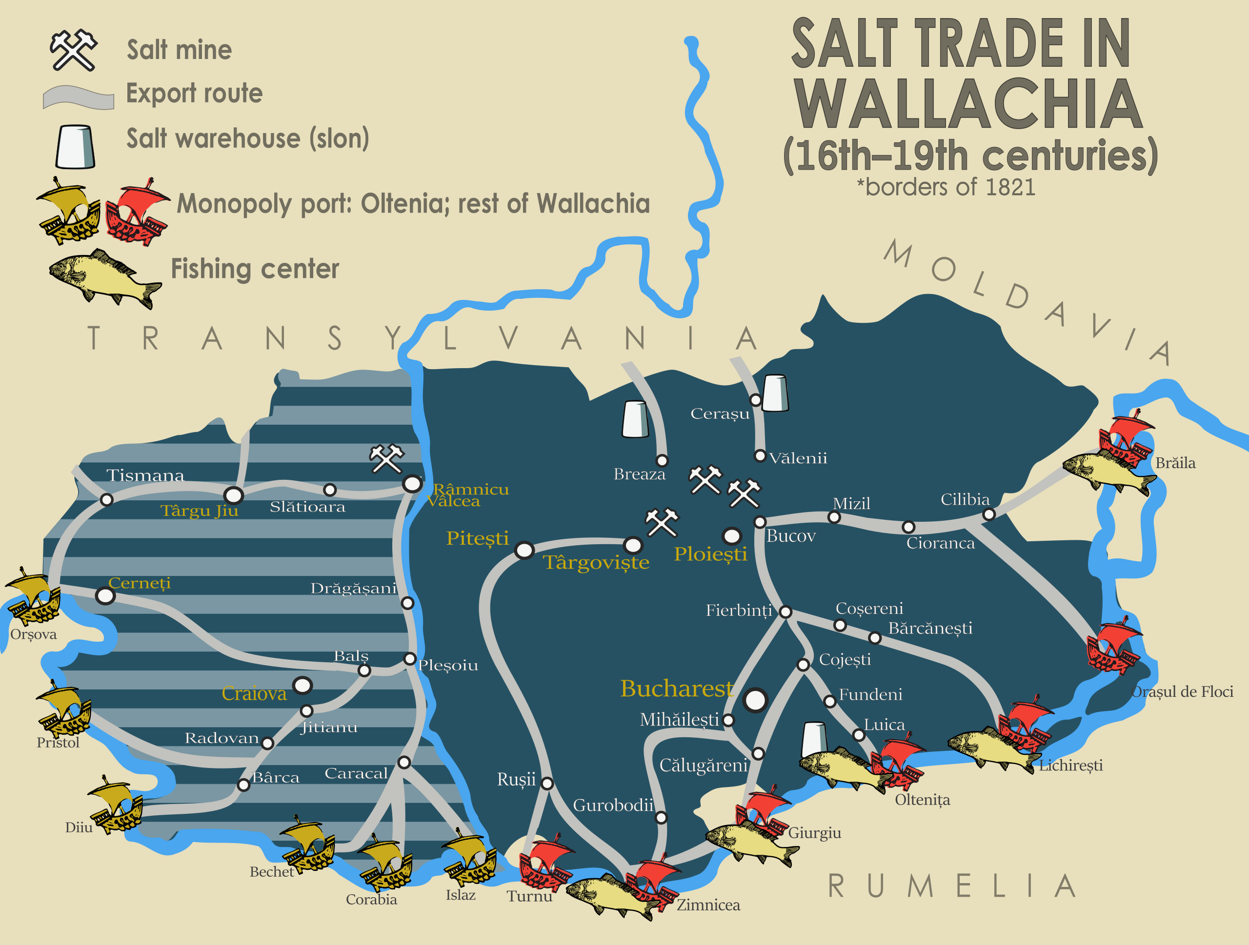
English: Map of the salt trade in Wallachia between the 16th and 19th centuries. Based on data from Aurora Ilieș, "Drumurile și transportul sării în Țara Românească", in Studii și Materiale de Istorie Medie, Vol. VII, 1974, pp. 223–242; and "La guerre du sel entre la Valachie et la Moldavie", in Revue des Études Sud-est Européennes, Vols. XXVII–XXVIII, 1999–2000, pp. 145–149. Detailed data on the roads and fisheries of Turnu–Zimnicea area from Ecaterina Țânțăreanu, Habitat medieval în sud-vestul Munteniei în sec. XIV–XVII. Temeiuri istorice și arheologice. Bucharest: Editura Renaissance, 2010. ISBN 978-973-8922-80-8. The commercial road linking Târgoviște and Turnu through Pitești is depicted in Eugenia Greceanu, Ansamblul urban medieval Pitești, p. 38. Bucharest: National Museum of Romanian History, 1982. OCLC 604144102. On the fisheries of Brăila, see: Camelia Hristian, Ghena Pricop, Evdochia Smaznov (eds.), Greci, evrei, ruși lipoveni, turci… Brăila. Reactivarea memoriei culturale a orașului. Brăila: Editura Istros, 2012. ISBN 978-606-654-035-3; on Lichirești: Pirin Boiagiev, "Din relațiile economice și demografice dintre Călărași și Silistra", in Cultură și Civilizație la Dunărea de Jos, Vols. XIII–XIV, 1995, pp. 259–262. |
| Date | |
| Source | Own work |
| Author | Dahn |
Licensing
[edit].svg&action=edit§ion=2)
I, the copyright holder of this work, hereby publish it under the following license:
This file is licensed under the Creative Commons Attribution-Share Alike 4.0 International license.
- You are free:
- to share – to copy, distribute and transmit the work
- to remix – to adapt the work
- Under the following conditions:
- attribution – You must give appropriate credit, provide a link to the license, and indicate if changes were made. You may do so in any reasonable manner, but not in any way that suggests the licensor endorses you or your use.
- share alike – If you remix, transform, or build upon the material, you must distribute your contributions under the same or compatible license as the original.
File history
Click on a date/time to view the file as it appeared at that time.
| Date/Time | Thumbnail | Dimensions | User | Comment | |
|---|---|---|---|---|---|
| current | 10:59, 19 February 2018 | | 1,003 × 759 (1.87 MB) | Dahn (talk | contribs) | var. tweaks |
| 09:23, 19 February 2018 |  | 1,003 × 759 (1.72 MB) | Dahn (talk | contribs) | fixed obscured writing | |
| 09:14, 19 February 2018 |  | 1,003 × 759 (1.72 MB) | Dahn (talk | contribs) | added data | |
| 23:15, 18 February 2018 |  | 1,003 × 759 (1.03 MB) | Dahn (talk | contribs) | border fixes | |
| 23:14, 18 February 2018 |  | 1,003 × 759 (1.03 MB) | Dahn (talk | contribs) | User created page with UploadWizard |
You cannot overwrite this file.
File usage on Commons
The following 6 pages use this file:
- User:Chumwa/OgreBot/Potential transport maps/2018 February 10-18
- User:Chumwa/OgreBot/Potential transport maps/2018 February 19-28
- User:Chumwa/OgreBot/Transport Maps/2018 February 10-18
- User:Chumwa/OgreBot/Transport Maps/2018 February 19-28
- User:Chumwa/OgreBot/Travel and communication maps/2018 February 10-18
- User:Chumwa/OgreBot/Travel and communication maps/2018 February 19-28
File usage on other wikis
The following other wikis use this file:
Metadata
.svg&oldid=445239099)
Categories:
- Maps of Wallachia
- Maps of the history of Romania in the Middle Ages
- Maps of the history of Early Modern Romania
- Maps of the history of modern Romania
- Maps of the lower Danube
- Mining in Romania
- Food of Romania
- Commerce in Romania
- History of transport in Romania
- Road maps of Romania
- Water transport in Romania
- Water transport maps
- Salt trade