File:Rus-1389.png
Jump to navigation
Jump to search
Size of this preview: 800 × 588 pixels. Other resolutions: 320 × 235 pixels | 640 × 471 pixels | 1,024 × 753 pixels | 1,280 × 941 pixels | 2,560 × 1,882 pixels | 3,548 × 2,609 pixels.
Original file (3,548 × 2,609 pixels, file size: 258 KB, MIME type: image/png)
Captions
Captions
Add a one-line explanation of what this file represents
Summary
[edit]| Description |
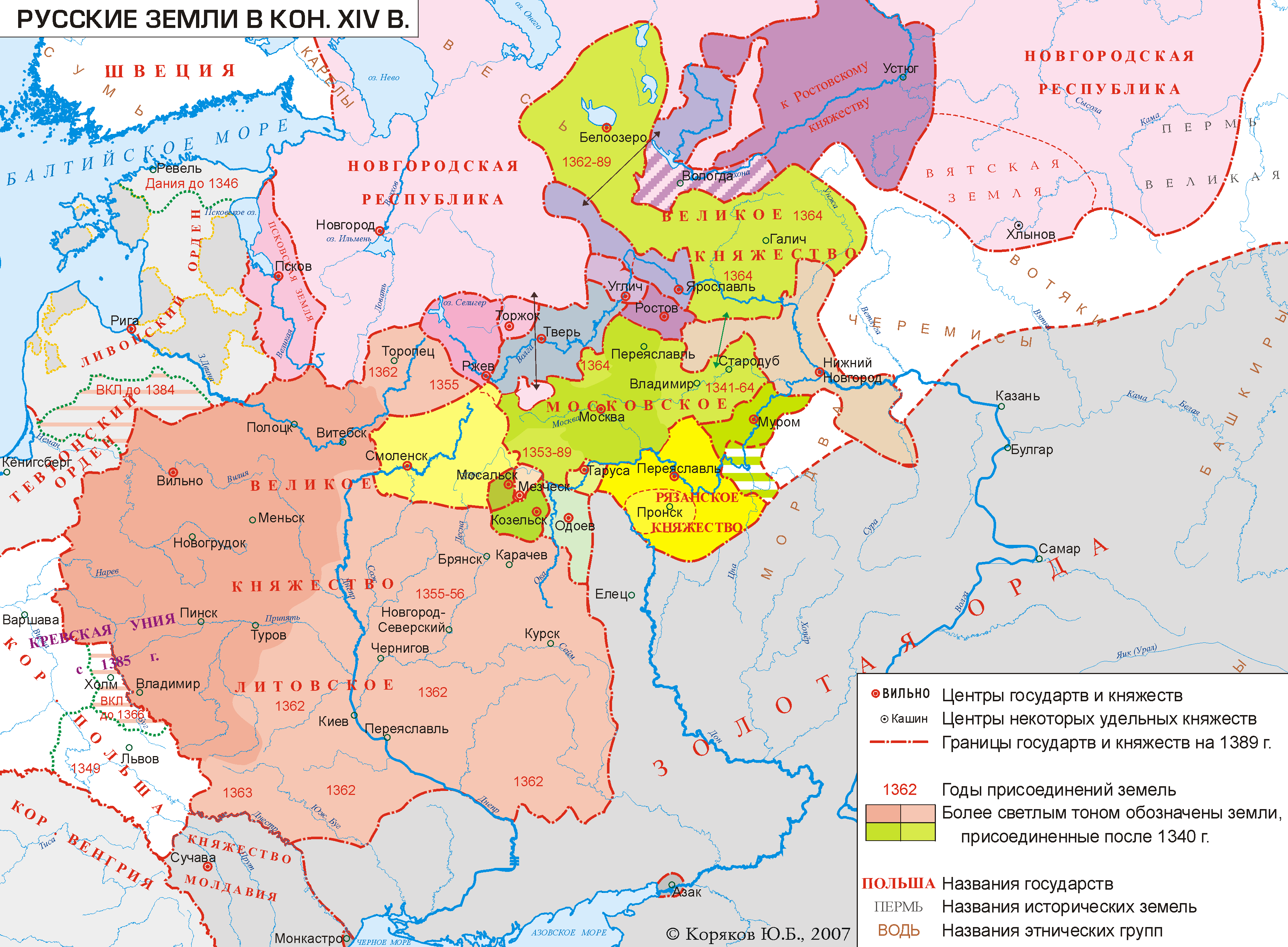
English: Rus' in 1389
Русский: Русские земли в 1389 году. |
| Date | |
| Source |
Own work Underlying (geographical) base map created on base of data from OpenStreetMap data (via gis-lab.info) vectorized with ESRI ArcView and edited in CorelDraw8.0. |
| Author | Koryakov Yuri |
| Permission (Reusing this file) |
I, the copyright holder of this work, hereby publish it under the following license: This file is licensed under the Creative Commons Attribution-Share Alike 2.5 Generic license.
|
| Other versions |


|
This historical map image could be re-created using vector graphics as an SVG file. This has several advantages; see Commons:Media for cleanup for more information. If an SVG form of this image is available, please upload it and afterwards replace this template with
{{vector version available|new image name}}.
It is recommended to name the SVG file “Rus-1389.svg”—then the template Vector version available (or Vva) does not need the new image name parameter. |
File history
Click on a date/time to view the file as it appeared at that time.
| Date/Time | Thumbnail | Dimensions | User | Comment | |
|---|---|---|---|---|---|
| current | 23:30, 26 March 2013 | | 3,548 × 2,609 (258 KB) | Ras67 (talk | contribs) | cropped |
| 11:37, 29 January 2007 |  | 3,574 × 2,639 (310 KB) | Koryakov Yuri (talk | contribs) | Rus' in 1389 |
You cannot overwrite this file.
File usage on Commons
The following 4 pages use this file:
File usage on other wikis
The following other wikis use this file:
- Usage on az.wikipedia.org
- Usage on ba.wikipedia.org
- Usage on be.wikipedia.org
- Usage on cs.wikipedia.org
- Usage on en.wikipedia.org
- Usage on es.wikipedia.org
- Usage on et.wikipedia.org
- Usage on fa.wikipedia.org
- Usage on fr.wikipedia.org
- Usage on he.wikipedia.org
- Usage on hu.wikipedia.org
- Usage on it.wikipedia.org
- Usage on ko.wikipedia.org
- Usage on la.wikipedia.org
- Usage on lt.wikipedia.org
- Usage on lt.wikibooks.org
- Usage on lv.wikipedia.org
- Maskavija
- Polockas kņazi
- Novgorodas kņazi
- Pleskavas kņazi
- Smoļenskas kņazi
- Volīnijas kņazi
- Galīcijas-Volīnijas kņazi
- Turovas-Pinskas kņazi
- Čerņihivas kņazi
- Tveras kņazi
- Rjazaņas kņazi
- Novgorodas-Severskas kņazi
- Vitebskas kņazi
- Minskas kņazi
- Lietuvas—Maskavijas kari
- Perma (zeme)
- Vjatka (zeme)
- Rostovas kņazi
- Usage on nl.wikipedia.org
- Usage on pl.wikipedia.org
View more global usage of this file.
Categories:
- Maps of Rus' principalities
- Maps of the Republic of Novgorod
- Maps of the Grand Principality of Moscow
- Maps of the history of Moldova
- 1389
- Maps of the history of Russia in Russian
- Maps of the territorial evolution of Russia
- Grand Duchy of Tver
- Grand Duchy of Ryazan
- Maps of the Bashkirs
- Maps of the Grand Duchy of Lithuania