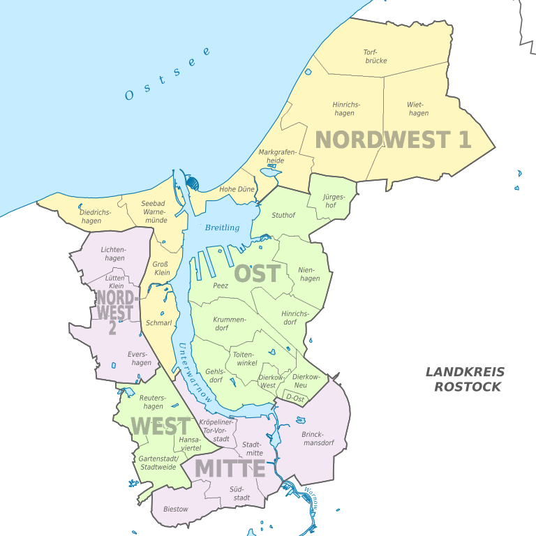
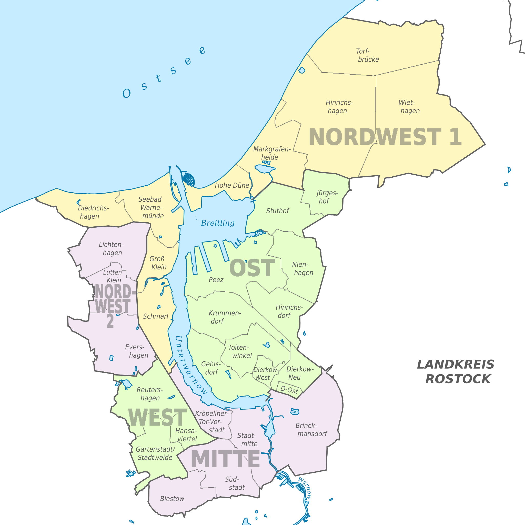
File:Rostock subdivisions.svg
Jump to navigation
Jump to search

Size of this PNG preview of this SVG file: 600 × 600 pixels. Other resolutions: 240 × 240 pixels | 480 × 480 pixels | 768 × 768 pixels | 1,024 × 1,024 pixels | 2,048 × 2,048 pixels | 1,380 × 1,380 pixels.
Original file (SVG file, nominally 1,380 × 1,380 pixels, file size: 629 KB)
Captions
Captions
Add a one-line explanation of what this file represents
Summary
[edit]
| Description | |
| Date | |
| Source |
Own work This W3C-unspecified vector image was created with Adobe Illustrator. This SVG file was uploaded with Commonist. •File:Rostock Verwaltungsgliederung unbeschriftet.svg by N3MO •OpenStreetMap Data (© OpenStreetMap und Mitwirkende, CC-BY-SA) |
| Author |
TUBS |
Licensing
[edit]
This file is licensed under the Creative Commons Attribution-Share Alike 2.0 Generic license.
- You are free:
- to share – to copy, distribute and transmit the work
- to remix – to adapt the work
- Under the following conditions:
- attribution – You must give appropriate credit, provide a link to the license, and indicate if changes were made. You may do so in any reasonable manner, but not in any way that suggests the licensor endorses you or your use.
- share alike – If you remix, transform, or build upon the material, you must distribute your contributions under the same or compatible license as the original.

|
I'd greatly appreciate, that you attribute this media file to Wikimedia Commons, if used outside Wikipedia or Commons. For use in publications such as books, newspapers, blogs, websites, please insert here the following line:
|
File history
Click on a date/time to view the file as it appeared at that time.
| Date/Time | Thumbnail | Dimensions | User | Comment | |
|---|---|---|---|---|---|
| current | 09:31, 7 July 2012 | | 1,380 × 1,380 (629 KB) | TUBS (talk | contribs) | |
| 09:27, 7 July 2012 |  | 1,380 × 1,380 (374 KB) | TUBS (talk | contribs) | new structure, effective as of mid 2012 | |
| 10:38, 17 August 2010 |  | 1,380 × 1,380 (1.11 MB) | TUBS (talk | contribs) | {{Information |Description={{de|Lage von Ortsamt oder Stadtteil xy (siehe Dateiname) in Rostock, Mecklenburg-Vorpommern.}} {{en|Location of borough xy (see filename) in Rostock, [[:en:Mecklenb |
You cannot overwrite this file.
File usage on Commons
The following 34 pages use this file:
- File:Biestow in Rostock.svg
- File:Brinckmansdorf in Rostock.svg
- File:Diedrichshagen in Rostock.svg
- File:Dierkow-Neu in Rostock.svg
- File:Dierkow-Ost in Rostock.svg
- File:Dierkow-West in Rostock.svg
- File:Dierkow in Rostock.svg
- File:Evershagen in Rostock.svg
- File:Gartenstadt-Stadtweide in Rostock.svg
- File:Gehlsdorf in Rostock.svg
- File:Groß Klein in Rostock.svg
- File:Hansaviertel in Rostock.svg
- File:Hinrichsdorf in Rostock.svg
- File:Hinrichshagen in Rostock.svg
- File:Hohe Düne in Rostock.svg
- File:Jürgeshof in Rostock.svg
- File:Krummendorf in Rostock.svg
- File:Kröpeliner-Tor-Vorstadt in Rostock.svg
- File:Lichtenhagen in Rostock.svg
- File:Locator map Rostock Grundkarte.svg
- File:Lütten Klein in Rostock.svg
- File:Markgrafenheide in Rostock.svg
- File:Nienhagen in Rostock.svg
- File:Peez in Rostock.svg
- File:Reutershagen in Rostock.svg
- File:Schmarl in Rostock.svg
- File:Seebad Warnemünde in Rostock.svg
- File:Stadtmitte in Rostock.svg
- File:Stuthof in Rostock.svg
- File:Südstadt in Rostock.svg
- File:Toitenwinkel in Rostock.svg
- File:Torfbrücke in Rostock.svg
- File:Unmarkierte Map Rostock.svg
- File:Wiethagen in Rostock.svg
File usage on other wikis
The following other wikis use this file:
- Usage on de.wikipedia.org
- Usage on en.wikipedia.org
- Usage on es.wikipedia.org
- Usage on hu.wikipedia.org
- Usage on lb.wikipedia.org
- Usage on mk.wikipedia.org
- Usage on pt.wikipedia.org